
Thank you for supporting this site ❤️
Make a donation
Make a donation
Petrolia topographic map
Click on the map to display elevation.
Thank you for supporting this site ❤️
Make a donation
Make a donation
About this map
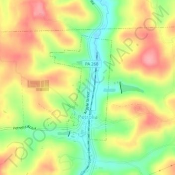
Name: Petrolia topographic map, elevation, terrain.
Location: Petrolia, Butler County, Pennsylvania, United States (41.01325 -79.72418 41.02950 -79.71232)
Average elevation: 405 m
Minimum elevation: 348 m
Maximum elevation: 456 m
Thank you for supporting this site ❤️
Make a donation
Make a donation
Other topographic maps
Click on a map to view its topography, its elevation and its terrain.
Glade Mills
United States > Pennsylvania > Butler County > Middlesex Township
Average elevation: 359 m
Thank you for supporting this site ❤️
Make a donation
Make a donation
Butler Farm Show Lake
United States > Pennsylvania > Butler County > Meridian
Average elevation: 392 m
Thank you for supporting this site ❤️
Make a donation
Make a donation