
Rangitoto Island topographic map
Interactive map
Click on the map to display elevation.
About this map
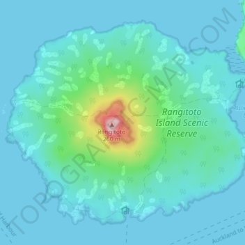
Name: Rangitoto Island topographic map, elevation, terrain.
Location: Rangitoto Island, Waiheke, Auckland, New Zealand (-36.80921 174.82822 -36.76295 174.89728)
Average elevation: 30 m
Minimum elevation: 0 m
Maximum elevation: 239 m
Other topographic maps
Click on a map to view its topography, its elevation and its terrain.
Waiheke Island
New Zealand > Auckland > Waiheke
Waiheke Island, Waiheke, Auckland, New Zealand
Average elevation: 16 m
Days Bay
New Zealand > Auckland > Waiheke
Days Bay, Waiheke, Auckland, New Zealand
Average elevation: 34 m
Hauraki Gulf
New Zealand > Auckland > Waiheke
Hauraki Gulf, Waiheke, Auckland, New Zealand
Average elevation: 55 m
Motutapu Island
New Zealand > Auckland > Waiheke
Motutapu Island, Waiheke, Auckland, New Zealand
Average elevation: 18 m
Rākino Island
New Zealand > Auckland > Waiheke
Rākino Island, Waiheke, Auckland, New Zealand
Average elevation: 6 m
Rangitoto
New Zealand > Auckland > Waiheke
Rangitoto, Waiheke, Auckland, New Zealand
Average elevation: 85 m
Pakatoa Island
New Zealand > Auckland > Waiheke
Pakatoa Island, Waiheke, Auckland, New Zealand
Average elevation: 1 m
Motuihe Island
New Zealand > Auckland > Waiheke
Motuihe Island, Waiheke, Auckland, New Zealand
Average elevation: 5 m
Ponui Island
New Zealand > Auckland > Waiheke
Ponui Island, Waiheke, Auckland, New Zealand
Average elevation: 15 m
Rotoroa Island
New Zealand > Auckland > Waiheke
Rotoroa Island, Waiheke, Auckland, New Zealand
Average elevation: 2 m
Waiheke Island
New Zealand > Auckland > Waiheke
Waiheke Island, Waiheke, Auckland, 1971, New Zealand
Average elevation: 36 m
Tarahiki Island (Shag Island)
New Zealand > Auckland > Waiheke
Tarahiki Island (Shag Island), Waiheke, Auckland, New Zealand
Average elevation: 0 m