
Thank you for supporting this site ❤️
Make a donation
Make a donation
Mount Sungay topographic map
Click on the map to display elevation.
Thank you for supporting this site ❤️
Make a donation
Make a donation
Mount Sungay
Mount Sungay is the eastern end of the Tagaytay Range, or more commonly known as the Tagaytay Ridge, a 32-kilometre (20 mi) ridge located at the southern part of the province with elevations averaging about 600 m (2,000 ft) above sea level. The ridge stretches west-southwest from Mount Sungay to Mount Batulao in Batangas province.
Thank you for supporting this site ❤️
Make a donation
Make a donation
About this map
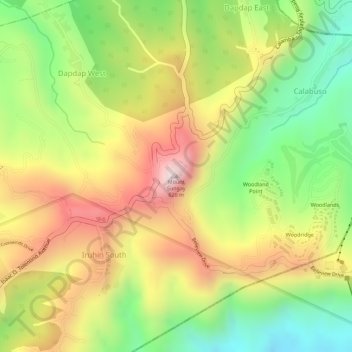
Name: Mount Sungay topographic map, elevation, terrain.
Average elevation: 501 m
Minimum elevation: 264 m
Maximum elevation: 728 m
Thank you for supporting this site ❤️
Make a donation
Make a donation
Other topographic maps
Click on a map to view its topography, its elevation and its terrain.