
Make a donation
Karakoram topographic map
Click on the map to display elevation.
Make a donation
Karakoram
The range contains 18 summits higher than 7,500 m (24,600 ft) in elevation, with four above 8,000 m (26,000 ft): K2 (8,611 m (28,251 ft) AMSL) (the second-highest peak on Earth), Gasherbrum I, Broad Peak, and Gasherbrum II.
Make a donation
About this map
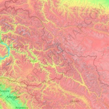
Name: Karakoram topographic map, elevation, terrain.
Location: Karakoram, Pakistan (34.12646 74.00116 36.93979 78.33446)
Average elevation: 4,414 m
Minimum elevation: 1,414 m
Maximum elevation: 8,508 m
Make a donation
Other topographic maps
Click on a map to view its topography, its elevation and its terrain.
Abbottabad
Pakistan > Khyber Pakhtunkhwa > Abbottabad District
Abbottabad (/ˈæbətəbɑːd/ AB-ə-tə-bahd; Urdu and Hindko: ایبٹ آباد, romanized: aibṭabād, pronounced [ɛːbʈəˈbaːd]) is a city in the Hazara Division of Khyber Pakhtunkhwa province, Pakistan. It is the 40th largest city in the country and 6th largest in the province by population, and…
Average elevation: 1,363 m
Make a donation
Dera Ismail Khan
Pakistan > Khyber Pakhtunkhwa > Dera Ismail Khan District
D. I Khan is situated at an altitude of 177 metres above sea level.
Average elevation: 177 m
Timergara
Pakistan > Khyber Pakhtunkhwa > Lower Dir District
Timergara (Pashto: تيمرګره, Urdu: تیمرگرہ) is a city and the district headquarters of the Lower Dir District and temporary headquarter of newly established Central Dir District in Khyber Pakhtunkhwa, Pakistan. Timergara city is located on the east bank of the Panjkora River. It lies at an…
Average elevation: 922 m
Make a donation
Mardan
Pakistan > Khyber Pakhtunkhwa > Mardan District
Mardan is located in the south west of the district at 34°12'0N 72°1'60E and an altitude of 283 metres (928 ft). Mardan is a district headquarter of Mardan District of Khyber Pakhtunkhwa. Risalpur is located to the south, Charsadda is located to the west, Yar Hussain to the east and Takht Bahi & Katlang to…
Average elevation: 328 m
Make a donation
Make a donation
Haji Dad Muhammad Lango
Pakistan > Balochistan > Nasirabad District > Mangle Kot
Average elevation: 64 m
Make a donation
Make a donation
Make a donation
Make a donation
Make a donation
Make a donation
Rawat Fort
Pakistan > Islamabad Capital Territory > Rawalpindi District > Channi Alam Sher > Dhoke Shah Alam Khan Number Dar
Average elevation: 562 m
Make a donation
Make a donation
Make a donation
Make a donation
Make a donation
Make a donation
Make a donation
Pahrianwali
Pahrianwali is a town in Mandi Bahauddin District in the Punjab province of Pakistan. It is located at 32°28'60N 73°46'0E at an altitude of 215 metres (708 feet). The village is part of Phalia tehsil. It is one of the biggest and populous town in Punjab. It has all served as central business district town…
Average elevation: 217 m
Make a donation
Make a donation
Make a donation
Make a donation
Make a donation
Make a donation
Make a donation
Make a donation