
Make a donation
Lake Superior topographic map
Click on the map to display elevation.
Make a donation
Lake Superior
American limnologist J. Val Klump was the first person to reach the lowest depth of Lake Superior on July 30, 1985, as part of a scientific expedition, which at 122 fathoms 1 foot (733 ft or 223 m) below sea level is the second-lowest spot in the continental interior of the United States and the third-lowest spot in the interior of the North American continent after Great Slave Lake in the Northwest Territories of Canada (1,503 feet[458 m] below sea level) and Iliamna Lake in Alaska (942 feet [287 m] below sea level). (Though Crater Lake is the deepest lake in the United States and deeper than Lake Superior, Crater Lake's elevation is higher and consequently its deepest point is 4,229 feet (1,289 m) above sea level.)
Make a donation
About this map
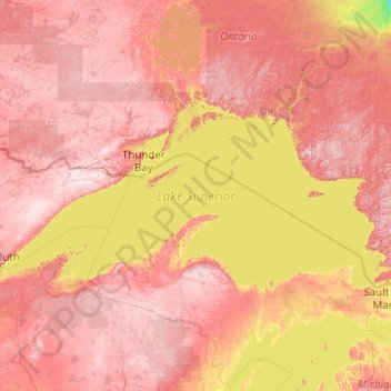
Name: Lake Superior topographic map, elevation, terrain.
Location: Lake Superior, United States (46.41024 -92.27277 49.01868 -84.35438)
Average elevation: 318 m
Minimum elevation: 101 m
Maximum elevation: 665 m
Make a donation
Other topographic maps
Click on a map to view its topography, its elevation and its terrain.
Flagstaff
United States > Arizona > Coconino County
Flagstaff, located in Coconino County, Arizona, is characterized by its diverse topography, primarily shaped by its high elevation and volcanic activity. Sitting at around 7,000 feet (approximately 2,130 meters), the city is surrounded by the expansive Coconino National Forest, which features a blend of…
Average elevation: 2,176 m
Baltimore
Baltimore exhibits a diverse topography that plays a significant role in its character and development. Situated along the Patapsco River, which flows into the Chesapeake Bay, the city is positioned on the fall line that separates the Piedmont Plateau to the west from the Atlantic Coastal Plain to the east.…
Average elevation: 65 m
Indianapolis
United States > Indiana > Indianapolis
Indianapolis is within the Tipton Till Plain, a flat to gently sloping terrain underlain by glacial deposits known as till. The lowest point in the city is about 650 feet (198 m) above mean sea level, with the highest natural elevation at about 900 feet (274 m) above sea level. Few hills or short ridges, known…
Average elevation: 241 m
Make a donation
Dallas
United States > Texas > Dallas County
Dallas and its surrounding area are mostly flat. The city lies at elevations ranging from 450 to 550 feet (137 to 168 m) above sea level. The western edge of the Austin Chalk Formation, a limestone escarpment (also known as the "White Rock Escarpment"), rises 230 feet (70 m) and runs roughly north–south…
Average elevation: 158 m
Twentynine Palms
United States > California > Twentynine Palms
According to the United States Census Bureau, the city has a total area of 59.1 square miles (153 km2), all land. The city is at an elevation of 1,988 feet (606 m). The Marine Corps Air Ground Combat Center Twentynine Palms is located there.
Average elevation: 690 m
Make a donation
Snoqualmie Pass
United States > Washington > King County
Due to its elevation, Snoqualmie Pass experiences significantly lower temperatures than Seattle, and receives much more precipitation, much of it being snow. Snoqualmie Pass has a humid continental climate (Koppen: Dsb bordering Csb) with cold, very wet and snowy winters, and mild to warm, relatively dry…
Average elevation: 1,048 m
Make a donation
Bozeman
United States > Montana > Gallatin County
Bozeman is located at an elevation of 4,820 feet (1,470 m). The Bridger Mountains are to the north-northeast, the Tobacco Root Mountains to the west-southwest, the Big Belt Mountains and Horseshoe Hills to the northwest, the Hyalite Peaks of the northern Gallatin Range to the south and the Spanish Peaks of the…
Average elevation: 1,679 m
Make a donation
Make a donation
Bakersfield
United States > California > Kern County > Bakersfield
Most of Bakersfield’s major streets are six-lane divided roads with bike lanes, with almost every street in the city having proper lane signage for bicycle traffic. Bikes are a popular method of transportation in Bakersfield, due to the city’s relatively flat topography and grid-like street system. Newer…
Average elevation: 161 m
Yucca Valley
United States > California > San Bernardino County
Yucca Valley lies in the middle of the Morongo Basin at a base elevation of 3,300 feet. Joshua Tree National Park is adjacent to its southern border.
Average elevation: 1,106 m
Make a donation
Pollock Pines
United States > California > El Dorado County
Pollock Pines is a census-designated place (CDP) in El Dorado County, California, United States. It is part of the Sacramento–Arden-Arcade–Roseville Metropolitan Statistical Area. Pollock Pines lies at an elevation of 3,980 feet (1,210 m) in the Sierra Nevada. The population was 6,871 at the 2010 census,…
Average elevation: 1,122 m
Fraser
United States > Colorado > Grand County
Fraser is located in southeastern Grand County at 39°56′39″N 105°48′48″W / 39.94417°N 105.81333°W / 39.94417; -105.81333 (39.944158, -105.813355), at an elevation of 8,574 feet (2,613 m) above sea level. It is bordered to the south by the town of Winter Park and to the north by…
Average elevation: 2,696 m
Make a donation
Ponce
United States > Puerto Rico > Ponce
Elevations include Cerro de Punta at 4,390 feet (1,338 m), the highest in Puerto Rico, located in Barrio Anón in the territory of the municipality of Ponce. Mount Jayuya, at 4,314 feet (1,315 m) is located on the boundary between Barrio Anón and Barrio Saliente in Jayuya. Cerro Maravilla, at nearly 3,970…
Average elevation: 189 m
Fairbanks
United States > Alaska > Fairbanks North Star
Fairbanks is situated within the central Tanana Valley, characterized by a diverse and dynamic topography. The city straddles the Chena River, which flows southwest into the larger Tanana River, defining Fairbanks' southern border. To the north, a gradual incline leads into a chain of hills that ascend toward…
Average elevation: 146 m
Rancho Santa Fe
The climate of Rancho Santa Fe is, for the most part, typical of the San Diego metropolitan area though its higher elevation and inland location lends itself to larger temperature variations.
Average elevation: 62 m
Horseshoe Bay
United States > Texas > Llano County > Horseshoe Bay > Horseshoe Bay
Average elevation: 286 m
Make a donation
Placerville
United States > California > Placerville
The region east of Placerville, popularly known as Apple Hill and Pleasant Valley, is becoming a center for wine production. The wine region is officially designated as the El Dorado AVA. The largest wineries in the area are Boeger, Lava Cap and Madrona, but most of the 30 plus wineries surrounding Placerville…
Average elevation: 587 m
Make a donation
White River
United States > Indiana > Marion County > Indianapolis > Ravenswood
Average elevation: 227 m
Make a donation
Air Force Academy
United States > Colorado > El Paso County > Colorado Springs
The campus of the academy covers 18,455 acres (29 sq mi; 75 km2) on the east side of the Rampart Range of the Rocky Mountains, just north of Colorado Springs. Its elevation is normally given as 7,258 feet (2,212 m) above sea level, which is at the cadet area. The academy was designed by Skidmore, Owings and…
Average elevation: 2,158 m
Make a donation
Hudson
United States > Florida > Hudson
Hudson features a predominantly flat and low-lying topography typical of the region, with an average elevation of approximately 16 feet above sea level. This terrain is interspersed with various wetlands and small lakes, creating a rich ecosystem that supports diverse wildlife. The area also includes a few…
Average elevation: 5 m
Make a donation
Lynx Lake
United States > Arizona > Yavapai County
Lynx Lake, Arizona, is a 55-acre (220,000 m2) reservoir located within Prescott National Forest, approximately 5 miles (8.0 km) east of Prescott, Arizona, in the Bradshaw Mountains. The lake is located at 5,530 feet (1,690 m) elevation and is stocked for fishing. It is one of the most popular recreation areas…
Average elevation: 1,726 m
Make a donation
Cincinnati
United States > Ohio > Hamilton County
Cincinnati has several standard modes of transportation including sidewalks, roads, public transit, bicycle paths and airports. The city's hills preclude the regular street grid common to many cities built up in the 19th century, and outside of the downtown basin, regular street grids are rare except for in…
Average elevation: 225 m
Make a donation
River Edge
United States > New Jersey > Bergen County > River Edge > River Edge
Average elevation: 21 m
Crater of Diamonds State Park
United States > Arkansas > Pike County > Murfreesboro > Kimberley
Average elevation: 106 m
Make a donation
Make a donation
Make a donation
Diamondhead
United States > Mississippi > Hancock County
Much of the land that became Diamondhead had been purchased by Walter Gex, Sr., in 1937 from the Gulf State Paper Company and the Easy Opener Bag Company. Additional land was purchased by Gex, bringing his acquisition to nearly 5,000 acres (2,000 ha). In the late 1960s, D.E.A.R., Inc., later known as the…
Average elevation: 3 m
Adjuntas
United States > Puerto Rico > Adjuntas
Adjuntas features a tropical rainforest climate that borders on a subtropical highland climate. While the town technically features a tropical rainforest climate, due to its high elevation, the climate is noticeably cooler than the norm for this climate category. Summers are warm (83°-85 °F) in the daytime…
Average elevation: 688 m
Sugarloaf
United States > California > San Bernardino County > Big Bear City
Average elevation: 2,154 m
Make a donation
Hot Springs National Park
United States > Arkansas > Garland County > Hot Springs
The National Park Service exercises no control or supervision over any matters connected with the city. The city starts on the other side of Central Avenue from Bathhouse Row. Its development has extended beyond the narrow valley in which the springs are located, spreading out over the open plain to the south…
Average elevation: 227 m
Make a donation
Silverton
United States > Colorado > San Juan County
According to the United States Census Bureau, the town has a total area of 0.8 square miles (2.1 km2), all of it land. Silverton is one of the highest towns in the United States, at 9,318 feet (2,840 m) above sea level. The town is located in San Juan County, the highest county in the United States, with a…
Average elevation: 2,991 m
Make a donation
Make a donation
Olean
United States > New York > Cattaraugus County
As a result of its higher elevation, Olean has a cooler humid continental climate (Köppen Dfb) than the larger western New York cities with hot-summer humid continental climates (Dfa).
Average elevation: 551 m
Make a donation
Make a donation
Pinetop-Lakeside
United States > Arizona > Navajo County
Pinetop-Lakeside is nestled in the stunning White Mountains of northeastern Arizona, characterized by a varied topography that significantly influences its natural beauty and recreational opportunities. The terrain features elevations averaging around 6,795 feet, with rugged mountain landscapes interspersed…
Average elevation: 2,087 m
Fairhope
United States > Alabama > Baldwin County > Fairhope
According to the U.S. Census Bureau, the city has a total area of 12.0 square miles (31.1 km2), of which 0.019 square mile (0.05 km2), or 0.16%, is water. Its elevation ranges from sea level at the bay to 122 feet (37 m) in the city center.
Average elevation: 35 m
Volcano
United States > Hawaii > Hawaiʻi County
Its altitude ranges from below 2,800 feet (850 m) in the southeast to over 6,200 feet (1,900 m) at its uninhabited northern end. Due to this, Volcano features a subtropical highland climate (Köppen Cfb), with relatively uniform temperatures and abundant rainfall throughout the year, although rainfall is…
Average elevation: 1,144 m
Lodi
United States > California > San Joaquin County
Lodi is flat terrain at an elevation of approximately 50 feet (15 m) above mean sea level datum. Historically, land in the area has been used for grazing as well as for grain production.
Average elevation: 3 m
Make a donation
Solvang
United States > California > Santa Barbara County
Solvang is located at 34°35′38″N 120°8′23″W / 34.59389°N 120.13972°W / 34.59389; -120.13972. At an elevation of 505 ft (154 m), it lies in the Santa Ynez Valley some 46 miles (74 km) north-west of Santa Barbara and about 15 miles (24 km) north of the Pacific coast. According to the United…
Average elevation: 194 m
Algiers Point
United States > Louisiana > Orleans Parish > New Orleans > Algiers
Average elevation: 3 m
Make a donation