
Make a donation
Chautauqua County topographic map
Click on the map to display elevation.
Make a donation
Chautauqua County
The county is generally composed of rolling hills and valleys, with elevations ranging anywhere between 1100 and 2100 feet, although the land within a few miles of Lake Erie is generally flat and at an elevation of 1000 feet or lower. The lowest point in the county is Lake Erie, at 571 feet (174 meters), and the highest point is Gurnsey Benchmark at 2,180 feet (660 meters).
Make a donation
About this map
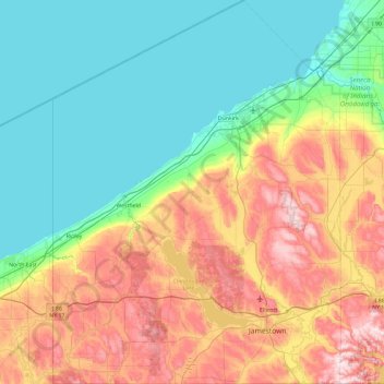
Name: Chautauqua County topographic map, elevation, terrain.
Location: Chautauqua County, New York, United States (41.99833 -79.76198 42.69143 -79.05921)
Average elevation: 328 m
Minimum elevation: 170 m
Maximum elevation: 668 m
Make a donation
Other topographic maps
Click on a map to view its topography, its elevation and its terrain.
Make a donation
Make a donation
Central Park
United States > New York > New York County > New York
In June 1856, Fernando Wood appointed a "consulting board" of seven people, headed by author Washington Irving, to inspire public confidence in the proposed development. Wood hired military engineer Egbert Ludovicus Viele as the park's chief engineer, tasking him with a topographical survey of the site. The…
Average elevation: 26 m
Make a donation
Quaker Ridge
United States > New York > Westchester County > City of New Rochelle
Average elevation: 65 m
Make a donation