
TR topographic map
Interactive map
Click on the map to display elevation.
About this map
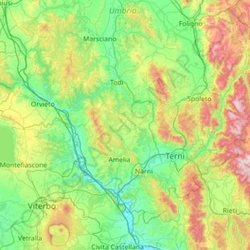
Name: TR topographic map, elevation, terrain.
Location: TR, Umbrië, Italië (42.36445 11.89189 42.94313 12.89634)
Average elevation: 425 m
Minimum elevation: 32 m
Maximum elevation: 1,756 m
Other topographic maps
Click on a map to view its topography, its elevation and its terrain.
Trasimeense Meer
Italië > Umbrië > Tuoro sul Trasimeno
Trasimeense Meer, Lungolago, Borgio Torale, Tuoro sul Trasimeno, PG, Umbrië, 06069, Italië
Average elevation: 267 m