
Make a donation
Basque Country topographic map
Click on the map to display elevation.
Make a donation
Basque Country
The Basque Country region is dominated by a warm, humid and wet oceanic climate. The coastal area is part of Green Spain and by extension, the climate is similar for Bayonne and Biarritz as well. Inland areas in Navarre and the southern regions of the autonomous community are transitional, with continental Mediterranean climate, with somewhat wider temperature swings between seasons. The list only sources locations in Spain, but Bayonne/Biarritz have a very similar climate to nearby Hondarribia on the Spanish side of the border. The values do not apply to San Sebastián, since its weather station is at a higher elevation than the urban core, where temperatures are higher year-round and similar to those in Bilbao and Hondarribia.
Make a donation
About this map
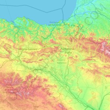
Name: Basque Country topographic map, elevation, terrain.
Location: Basque Country, Spain (41.90989 -3.45091 43.54743 -0.65272)
Average elevation: 560 m
Minimum elevation: -2 m
Maximum elevation: 2,626 m
Make a donation
Other topographic maps
Click on a map to view its topography, its elevation and its terrain.
Montenegral Alto
Spain > Andalusia > Campo de Gibraltar > San Martín del Tesorillo
Average elevation: 71 m
Pyrenees
The Pyrenees are a mountain range straddling the border of France and Spain. They extend nearly 500 km (310 mi) from their union with the Cantabrian Mountains to Cap de Creus on the Mediterranean coast, reaching a maximum altitude of 3,404 metres (11,168 ft) at the peak of Aneto.
Average elevation: 491 m
Make a donation
Make a donation
Make a donation
Soil
Spain > Autonomous Community of the Basque Country > Montaña Alavesa/Arabako Mendialdea
Average elevation: 898 m
Make a donation
Make a donation
Donostia / San Sebastián
Spain > Autonomous Community of the Basque Country > Donostialdea > Donostia / San Sebastián
Average elevation: 134 m
Santiago de Compostela
Spain > Galicia > Santiago > Santiago de Compostela
The cathedral borders the main plaza of the old and well-preserved city. According to medieval legend, the remains of the apostle James were brought to Galicia for burial; in 813, the light of a bright star guided a shepherd who was watching his flock at night to the burial site in Santiago de Compostela. This…
Average elevation: 248 m
Madrid
Spain > Community of Madrid > Área metropolitana de Madrid y Corredor del Henares > Madrid
Average elevation: 650 m
Make a donation
Penyagolosa
Spain > Valencian Community > Castelló / Castellón > Xodos / Chodos
Average elevation: 1,417 m
Make a donation