
Make a donation
Gelsenkirchen topographic map
Click on the map to display elevation.
Make a donation
About this map
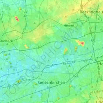
Name: Gelsenkirchen topographic map, elevation, terrain.
Location: Gelsenkirchen, North Rhine-Westphalia, Germany (51.48080 6.98750 51.63159 7.15234)
Average elevation: 57 m
Minimum elevation: 27 m
Maximum elevation: 197 m
Make a donation
Other topographic maps
Click on a map to view its topography, its elevation and its terrain.
Make a donation
Börninghausen
Germany > North Rhine-Westphalia > Kreis Minden-Lübbecke > Preußisch Oldendorf
Average elevation: 135 m
Make a donation
Dusseldorf
Germany > North Rhine-Westphalia
The Archbishop of Cologne's forces were wiped out by the forces of the count of Berg who were supported by citizens and farmers of Cologne and Düsseldorf, paving the way for Düsseldorf's elevation to city status, which is commemorated today by a monument on the Burgplatz. The custom of turning cartwheels is…
Average elevation: 63 m
Make a donation
Struberg
Germany > North Rhine-Westphalia > Kreis Minden-Lübbecke > Hüllhorst
Average elevation: 191 m
Lüderich
Germany > North Rhine-Westphalia > Rheinisch-Bergischer Kreis > Rösrath
Average elevation: 168 m
Make a donation
Make a donation
Meckenheim
Germany > North Rhine-Westphalia > Rhein-Sieg-Kreis > Meckenheim > Meckenheim
Average elevation: 190 m
Horn-Bad Meinberg
Germany > North Rhine-Westphalia > Kreis Lippe
In the municipality are the two highest peaks of the Eggegebirge, the Lipp Velmerstot (441 m) and the Prussian Velmerstot with about (464 m) above sea level and the highest elevation of the Teutoburg forest, the Barnacken with (446 m). The deepest point of the metropolitan area is (125 m). Between the…
Average elevation: 240 m
Make a donation
Hilchenbach
Germany > North Rhine-Westphalia > Kreis Siegen-Wittgenstein > Hilchenbach > Hilchenbach
Average elevation: 465 m
Make a donation
Blockhaus
Germany > North Rhine-Westphalia > Oberbergischer Kreis > Reichshof > Blockhaus
Average elevation: 409 m
Gummersbach
Germany > North Rhine-Westphalia > Oberbergischer Kreis > Gummersbach > Gummersbach
Average elevation: 308 m
Make a donation
Siegen
Germany > North Rhine-Westphalia > Kreis Siegen-Wittgenstein > Siegen
The city's total land area is roughly 115 km2 (44 sq mi). Its greatest east-west span is about 12 km (7 mi), and its greatest north-south span is about 12 km (7 mi). City limits are 48 km (30 mi) long. Siegen lies at a median elevation of 290 m (951 ft) above sea level. The city's greatest elevation is the…
Average elevation: 401 m
Breckerfeld
Germany > North Rhine-Westphalia > Ennepe-Ruhr-Kreis > Breckerfeld > Breckerfeld
Average elevation: 342 m
Winterberg
Germany > North Rhine-Westphalia > Hochsauerlandkreis > Winterberg > Winterberg
Average elevation: 648 m
Ebbegebirge
Germany > North Rhine-Westphalia > Märkischer Kreis > Herscheid
The highest elevation in the Ebbe Mountains is the Nordhelle (663.3 m above NN) between Valbert and Herscheid. Other notable hills are the: Rehberg (645.9 m), Rüenhardt (636.0 m), Waldberg (ca. 635 m), Rothenstein (ca. 600 m), Der Griesing (552,6 m), Homert (538,3 m) and Kahler Kopf (540.1 m).
Average elevation: 550 m
Make a donation
Make a donation
Hommerich
Germany > North Rhine-Westphalia > Rhein-Sieg-Kreis > Hennef (Sieg) > Hofen
Average elevation: 156 m