
Make a donation
Dusseldorf topographic map
Click on the map to display elevation.
Make a donation
Dusseldorf
The Archbishop of Cologne's forces were wiped out by the forces of the count of Berg who were supported by citizens and farmers of Cologne and Düsseldorf, paving the way for Düsseldorf's elevation to city status, which is commemorated today by a monument on the Burgplatz. The custom of turning cartwheels is credited to the children of Düsseldorf. There are variations of the origin of the cartwheeling children. Today the symbol (Der Radschläger) represents the story and every year the Düsseldorfers celebrate by having a cartwheeling contest. After this battle the relationship between the four cities deteriorated, because they were commercial rivals; it is often said that there is a kind of hostility between the citizens of Cologne and Düsseldorf. Today, it finds its expression mainly in a humorous form (especially during the Rhineland Karneval) and in sports.
Make a donation
About this map
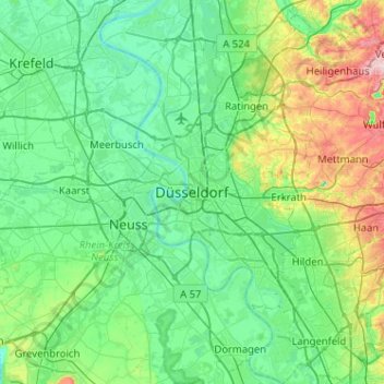
Name: Dusseldorf topographic map, elevation, terrain.
Location: Dusseldorf, North Rhine-Westphalia, Germany (51.06540 6.61631 51.38540 6.93631)
Average elevation: 63 m
Minimum elevation: 13 m
Maximum elevation: 260 m
Make a donation
Other topographic maps
Click on a map to view its topography, its elevation and its terrain.
Make a donation
Make a donation
Hemer
Germany > North Rhine-Westphalia > Märkischer Kreis
Hemer is located at the north end of the Sauerland near the Ruhr river. The highest elevation, at 546 metres (1,791 feet), is in the Balver Wald in the south of the city. The lowest elevation, at 160 metres (520 feet), is at the Edelburg in the northeast.
Average elevation: 326 m
Make a donation
Siegen
Germany > North Rhine-Westphalia > Kreis Siegen-Wittgenstein
The city's total land area is roughly 115 km2 (44 sq mi). Its greatest east-west span is about 12 km (7 mi), and its greatest north-south span is about 12 km (7 mi). City limits are 48 km (30 mi) long. Siegen lies at a median elevation of 290 m (951 ft) above sea level. The city's greatest elevation is the…
Average elevation: 346 m
Make a donation
33813
Germany > North Rhine-Westphalia > Kreis Lippe > Oerlinghausen > Oerlinghausen
Average elevation: 226 m
Make a donation
Make a donation
Make a donation
Niedersetzen
Germany > North Rhine-Westphalia > Kreis Siegen-Wittgenstein > Siegen
Average elevation: 321 m
Make a donation
Meinerzhagen
Germany > North Rhine-Westphalia > Märkischer Kreis
Meinerzhagen is located in the hills of the Sauerland. The highest elevation is the Nordhelle with 652 m above sea level, the lowest elevation at the Lister dam with 319m. 56% of the town area is covered by forests.
Average elevation: 419 m
Make a donation
Make a donation
Make a donation
Rheda-Wiedenbrück
Germany > North Rhine-Westphalia > Kreis Gütersloh
The length of the city border is 50,2 km, the highest elevation at 105m and the lowest point at 66m above mean sea level.
Average elevation: 80 m
Make a donation
Hahn
Germany > North Rhine-Westphalia > Oberbergischer Kreis > Wiehl > Brächen
Average elevation: 277 m
Make a donation
Make a donation
Make a donation
Make a donation
Make a donation
Rommerskirchen
Germany > North Rhine-Westphalia > Rhein-Kreis Neuss > Rommerskirchen
Average elevation: 77 m