
Thank you for supporting this site ❤️
Make a donation
Make a donation
Putnam County topographic map
Click on the map to display elevation.
Thank you for supporting this site ❤️
Make a donation
Make a donation
About this map
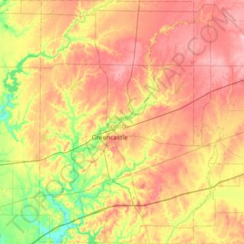
Name: Putnam County topographic map, elevation, terrain.
Location: Putnam County, Indiana, United States (39.47006 -87.01462 39.86742 -86.64164)
Average elevation: 243 m
Minimum elevation: 177 m
Maximum elevation: 309 m
Thank you for supporting this site ❤️
Make a donation
Make a donation
Other topographic maps
Click on a map to view its topography, its elevation and its terrain.
Thank you for supporting this site ❤️
Make a donation
Make a donation
Indiana Dunes State Park
United States > Indiana > Porter County > Chesterton
Average elevation: 186 m
Drexel Gardens
United States > Indiana > Marion County > Indianapolis > Drexel Gardens
Average elevation: 226 m
Thank you for supporting this site ❤️
Make a donation
Make a donation