
Thank you for supporting this site ❤️
Make a donation
Make a donation
Buuri topographic map
Click on the map to display elevation.
Thank you for supporting this site ❤️
Make a donation
Make a donation
About this map
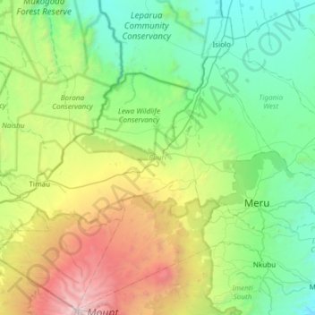
Name: Buuri topographic map, elevation, terrain.
Location: Buuri, Meru County, Eastern, Kenya (-0.05463 37.09070 0.32646 37.68634)
Average elevation: 1,980 m
Minimum elevation: 944 m
Maximum elevation: 5,086 m
Thank you for supporting this site ❤️
Make a donation
Make a donation
Other topographic maps
Click on a map to view its topography, its elevation and its terrain.