
Nukutawhiti topographic map
Interactive map
Click on the map to display elevation.
About this map
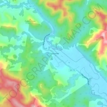
Name: Nukutawhiti topographic map, elevation, terrain.
Location: Nukutawhiti, Whangarei District, Northland, New Zealand (-35.66168 173.83677 -35.62168 173.87677)
Average elevation: 117 m
Minimum elevation: 32 m
Maximum elevation: 321 m
Whangarei District trails, hiking, mountain biking, running and outdoor activities
Other topographic maps
Click on a map to view its topography, its elevation and its terrain.