Geolocate

Manicaland Province topographic map

Interactive map

Click on the map to display elevation.

Manicaland Province topographic map, elevation, terrain

Manicaland Province topographic map, elevation, terrain

About this map

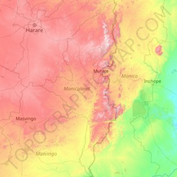
Name: Manicaland Province topographic map, elevation, terrain.

Location: Manicaland Province, Zimbabwe (-21.32857 31.18733 -17.24838 33.06835)

Average elevation: 784 m

Minimum elevation: 4 m

Maximum elevation: 2,489 m

Other topographic maps

Click on a map to view its topography, its elevation and its terrain.

Midlands Province

Zimbabwe

Average elevation: 1,117 m

Bulawayo Province

Zimbabwe

Under the Köppen climate classification, Bulawayo features a hot semi-arid climate (BSh). Due to its relatively high altitude, the city has fairly moderate temperatures despite lying in the tropics. The mean annual temperature is 19.16 °C (66.49 °F), similar to Pretoria at a similar altitude but almost 600…

Average elevation: 1,321 m

Masvingo Province

Zimbabwe

Average elevation: 700 m

Harare

Zimbabwe

Harare (/həˈrɑːreɪ/ hə-RAR-ay), formerly known as Salisbury (/ˈsɔːlzbəri/ SAWLZ-bər-ee), is the capital and largest city of Zimbabwe, and is the most populous city in the country. The city proper has an area of 982.3km2 (378.7 mi2), a population of 1,849,600 as of the 2022 census and an estimated…

Average elevation: 1,461 m

Mutasa

Zimbabwe > Manicaland Province

Average elevation: 1,262 m

Runanga

Zimbabwe > Mashonaland East Province > Goromonzi

Average elevation: 1,500 m

Shurugwi

Zimbabwe > Midlands

Average elevation: 1,182 m

Mashonaland Central Province

Zimbabwe

Average elevation: 859 m

Bulawayo

Zimbabwe > Bulawayo Province > Bulawayo

Average elevation: 1,348 m

Mount Nyangani

Zimbabwe > Manicaland

Average elevation: 2,329 m

Zaka

Zimbabwe > Masvingo > Zaka

Average elevation: 757 m