
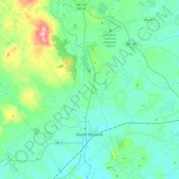
North Berwick topographic map
Interactive map
Click on the map to display elevation.
North Berwick topographic map, elevation, terrain
North Berwick
According to the United States Census Bureau, the town has a total area of 38.16 square miles (98.83 km2), of which, 38.02 square miles (98.47 km2) of it is land and 0.14 square miles (0.36 km2) is water. North Berwick is drained by the Great Works River and its tributary, the Negutaquet River. Bauneg Beg Hill, elevation 866 feet (264 m) above sea level, is the town's highest point.
About this map
Name: North Berwick topographic map, elevation, terrain.
Location: North Berwick, York County, Maine, 03906, United States (43.26976 -70.85723 43.41668 -70.70928)
Average elevation: 75 m
Minimum elevation: 29 m
Maximum elevation: 257 m
Other topographic maps
Click on a map to view its topography, its elevation and its terrain.
Berwick
United States > Maine > York County
According to the United States Census Bureau, the town has a total area of 37.86 square miles (98.06 km2), of which, 37.52 square miles (97.18 km2) of it is land and 0.34 square miles (0.88 km2) is water. Berwick is drained by the Little River and Salmon Falls River. Diamond Hill, elevation 490 feet (149.4 m)…
Average elevation: 76 m