
Humberston topographic map
Interactive map
Click on the map to display elevation.
About this map
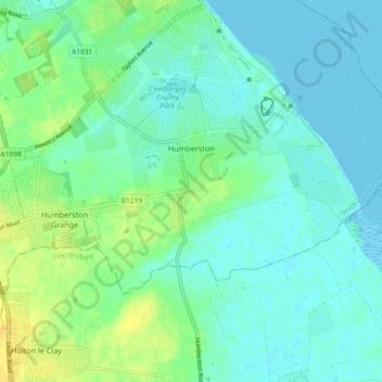
Name: Humberston topographic map, elevation, terrain.
Location: Humberston, North East Lincolnshire, England, United Kingdom (53.51307 -0.06129 53.54266 0.03031)
Average elevation: 7 m
Minimum elevation: -1 m
Maximum elevation: 21 m
Other topographic maps
Click on a map to view its topography, its elevation and its terrain.
Laceby
United Kingdom > England > North East Lincolnshire
Laceby, North East Lincolnshire, England, DN37 7BD, United Kingdom
Average elevation: 24 m
Grimsby
United Kingdom > England > North East Lincolnshire
Grimsby, North East Lincolnshire, England, DN31 1NR, United Kingdom
Average elevation: 6 m