
Wakefield topographic map
Click on the map to display elevation.
About this map
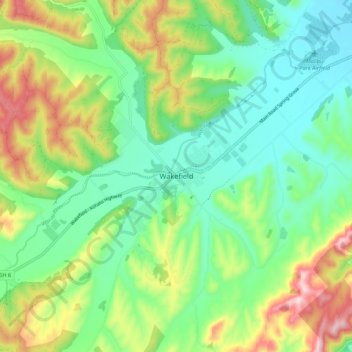
Name: Wakefield topographic map, elevation, terrain.
Location: Wakefield, Tasman, 7025, New Zealand (-41.44562 173.00283 -41.36562 173.08283)
Average elevation: 134 m
Minimum elevation: 29 m
Maximum elevation: 341 m
Tasman trails, hiking, mountain biking, running and outdoor activities
Other topographic maps
Click on a map to view its topography, its elevation and its terrain.