Geolocate

Abitibi-Ouest topographic map

Interactive map

Click on the map to display elevation.

About this map

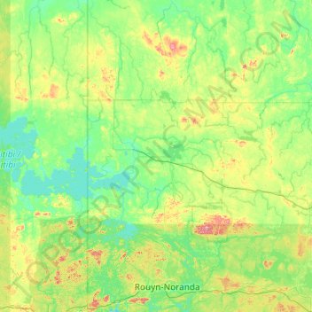
Name: Abitibi-Ouest topographic map, elevation, terrain.

Location: Abitibi-Ouest, Abitibi-Témiscamingue, Quebec, Canada (48.13511 -79.73061 49.41511 -78.45061)

Average elevation: 306 m

Minimum elevation: 261 m

Maximum elevation: 558 m

Other topographic maps

Click on a map to view its topography, its elevation and its terrain.

René-Levasseur Island

Canada > Quebec > Manicouagan

Average elevation: 450 m

Laval (administrative region)

Canada > Quebec

Average elevation: 42 m

Frampton

Canada > Quebec > La Nouvelle-Beauce

Average elevation: 373 m

Grenville

Canada > Quebec > Argenteuil

Average elevation: 49 m

Arrondissement de Chicoutimi

Canada > Quebec > Saguenay

Average elevation: 189 m

La Prairie

Canada > Quebec > Roussillon

Average elevation: 22 m

La Malbaie

Canada > Quebec > Charlevoix-Est

Average elevation: 312 m

Arrondissement de Jonquière

Canada > Quebec > Saguenay

Average elevation: 151 m

Val-Racine

Canada > Quebec > Le Granit

Average elevation: 558 m

Trois-Rivières

Canada > Quebec

Average elevation: 36 m

Beaupré

Canada > Quebec > La Côte-de-Beaupré

Average elevation: 199 m

Saint-Adelme

Canada > Quebec > La Matanie

Average elevation: 237 m

Val-d'Or

Canada > Quebec > La Vallée-de-l'Or

Val-d'Or is situated on the Canadian Shield at an elevation of 1100 feet (330m) above sea level. Although its name refers to a valley ("Val"), the city is actually situated on a vast, slightly undulating plain.

Average elevation: 331 m

Denholm

Canada > Quebec > La Vallée-de-la-Gatineau

Average elevation: 279 m

Saint-Zénon

Canada > Quebec > Matawinie

Average elevation: 488 m

L'Ange-Gardien

Canada > Quebec > La Côte-de-Beaupré

Average elevation: 155 m

Rawdon

Canada > Quebec > Matawinie

Average elevation: 197 m

Saint-Jean-de-Matha

Canada > Quebec > Matawinie

Average elevation: 236 m

Joliette

Canada > Quebec > Joliette (MRC)

Average elevation: 52 m

Saint-Michel-des-Saints

Canada > Quebec > Matawinie

Average elevation: 456 m

Drummond

Canada > Quebec

Average elevation: 100 m

Berry

Canada > Quebec > Abitibi

Average elevation: 310 m

Campbell's Bay

Canada > Quebec > Pontiac (MRC)

Average elevation: 128 m

Mont-Laurier

Canada > Quebec > Mont-Laurier

Average elevation: 296 m

Saint-Victor

Canada > Quebec > Saint-Victor

Average elevation: 309 m

Rimouski

Canada > Quebec > Rimouski-Neigette

Average elevation: 126 m

Tadoussac

Canada > Quebec > Tadoussac

Average elevation: 141 m

Authier

Canada > Quebec > Authier

Average elevation: 304 m

Quebec

Canada > Quebec > Urban agglomeration of Québec

Quebec City was built on the north bank of the Saint Lawrence River, where it narrows and meets the mouth of the Saint-Charles River. Old Quebec is located on top and at the foot of Cap-Diamant, which is on the eastern edge of a plateau called the promontory of Quebec (Quebec hill). Because of this topographic…

Average elevation: 122 m

Gore

Canada > Quebec > Argenteuil

Average elevation: 270 m

Rivière Nipissis

Canada > Quebec > Rivière-Nipissis

Average elevation: 473 m

Rivière-Koksoak

Canada > Quebec > Rivière-Koksoak

Average elevation: 211 m

Mont-Albert

Canada > Quebec > La Haute-Gaspésie

The territory is home to the Chic-Chocs Wildlife Reserve and Gaspésie National Park where the eponymous Mount Albert and Mont Jacques-Cartier are located. Mount Albert, with a 1,151-metre-high (3,776 ft) peak, is the 9th highest peak in Quebec. It was named in honour of Prince Albert of Saxe-Coburg and Gotha…

Average elevation: 427 m

Sutton

Canada > Quebec > Brome-Missisquoi

Average elevation: 298 m

Labelle

Canada > Quebec > Labelle

Average elevation: 306 m

Hatley

Canada > Quebec > Hatley

Average elevation: 294 m

Sorel-Tracy

Canada > Quebec

Average elevation: 16 m