
La Guajira topographic map
Interactive map
Click on the map to display elevation.
La Guajira
The department was divided into three subregions based on geographical characteristics: Upper, Middle, and Southern Guajira. The Upper Guajira covers the northernmost part of the peninsula, with mostly scarce semi-desertic vegetation. It has only an isolated, low-altitude mountain range, the Serranía de Macuira (865 m above sea level). The Middle Guajira region is mostly flat, with hills in some areas, presenting also an arid environment. The Southern Guajira covers the region of the Montes de Oca and the Serranía del Perijá mountain ranges on the border with Venezuela, and the valley formed with the Sierra Nevada de Santa Marta mountain range. Southern Guajira has more green vegetation, wetlands and rivers.
About this map
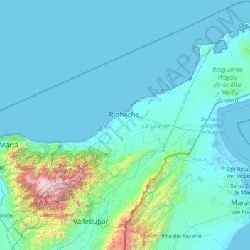
Name: La Guajira topographic map, elevation, terrain.
Location: La Guajira, RAP Caribe, Colombia (10.39671 -73.66464 12.45733 -71.11296)
Average elevation: 290 m
Minimum elevation: -6 m
Maximum elevation: 5,519 m
Other topographic maps
Click on a map to view its topography, its elevation and its terrain.
Andes
Andes is a municipality and town in the Antioquia Department, Colombia. Part of the sub-region of Southwestern Antioquia, it is located on the western Colombian Andes mountain range. Andes was founded on 13 March 1852 by Pedro Antonio Restrepo Escobar. Its elevation is 1,360 metres above sea level with an…
Average elevation: 1,559 m