
Pershing County topographic map
Interactive map
Click on the map to display elevation.
About this map
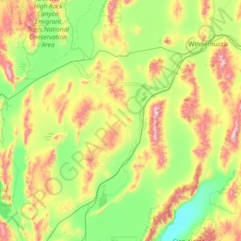
Name: Pershing County topographic map, elevation, terrain.
Location: Pershing County, Nevada, United States of America (39.99816 -119.33852 40.96106 -117.30002)
Average elevation: 1,449 m
Minimum elevation: 1,029 m
Maximum elevation: 2,962 m
According to the U.S. Census Bureau, the county has a total area of 6,067 square miles (15,710 km2), of which 6,037 square miles (15,640 km2) is land and 31 square miles (80 km2) (0.5%) is water. The tallest and most topographically prominent mountain in Pershing County is Star Peak at 9,840 ft (3,000 m).
Other topographic maps
Click on a map to view its topography, its elevation and its terrain.
Lincoln County
United States of America > Nevada
Lincoln County, Nevada, United States of America
Average elevation: 1,639 m
Lander County
United States of America > Nevada
Lander County, Nevada, United States of America
Average elevation: 1,768 m
Mesquite
United States of America > Nevada > Mesquite
Mesquite, Clark County, Nevada, United States of America
Average elevation: 601 m
Whitney
United States of America > Nevada > Whitney
Whitney, Clark County, Nevada, United States of America
Average elevation: 524 m
Clark County
United States of America > Nevada
Clark County, Nevada, United States of America
Average elevation: 968 m
North Valley
United States of America > Nevada > Reno > North Valley
North Valley, Reno, Washoe County, Nevada, 89512, United States of America
Average elevation: 1,419 m
Jackman
United States of America > Nevada > Jackman
Jackman, Clark County, Nevada, United States of America
Average elevation: 506 m
Elko County
United States of America > Nevada
Elko County, Nevada, United States of America
Average elevation: 1,838 m