
South Yorkshire topographic map
Interactive map
Click on the map to display elevation.
About this map
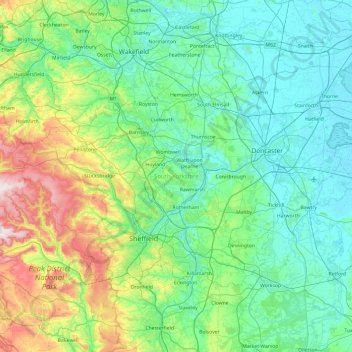
Name: South Yorkshire topographic map, elevation, terrain.
Average elevation: 123 m
Minimum elevation: 0 m
Maximum elevation: 630 m
Other topographic maps
Click on a map to view its topography, its elevation and its terrain.
Ashbourne CP
United Kingdom > England > Derbyshire > Derbyshire Dales
Ashbourne CP, Derbyshire Dales, Derbyshire, England, United Kingdom
Average elevation: 147 m
Crich Carr
United Kingdom > England > Derbyshire > Amber Valley
Crich Carr, Amber Valley, Derbyshire, England, DE4 5EJ, United Kingdom
Average elevation: 171 m
Nottingham Canal
United Kingdom > England > Derbyshire > Amber Valley > Langley Mill
Nottingham Canal, Aldercar and Langley Mill CP, Langley Mill, Amber Valley, Derbyshire, East Midlands, England, NG16 4AA, United Kingdom
Average elevation: 77 m
Derby
United Kingdom > England > Derbyshire
Derby, Derbyshire, England, DE1 2AA, United Kingdom
Average elevation: 96 m