
Waimakariri District topographic map
Interactive map
Click on the map to display elevation.
About this map
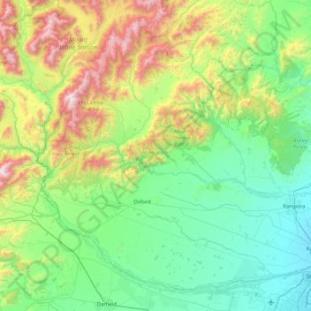
Name: Waimakariri District topographic map, elevation, terrain.
Location: Waimakariri District, Canterbury, New Zealand (-43.46078 171.92840 -42.95422 172.73605)
Average elevation: 476 m
Minimum elevation: 1 m
Maximum elevation: 1,930 m
Canterbury trails, hiking, mountain biking, running and outdoor activities
Other topographic maps
Click on a map to view its topography, its elevation and its terrain.
Fairlie
New Zealand > Canterbury > Mackenzie District
Fairlie is a Mackenzie District service town (or township) located in the Canterbury region of the South Island of New Zealand. The estimated population was 960 as of June 2024. Being on state highway 8 between Christchurch (182 km, 2 hours 20 minutes drive) and Queenstown (300 km 3.5 hours drive), tourism is…
Average elevation: 317 m
Mount Cook
New Zealand > Canterbury > Mackenzie District
Aoraki / Mount Cook is the highest mountain in New Zealand. Its height, as of 2014, is listed as 3,724 metres (12,218 feet). It is situated in the Southern Alps, the mountain range that runs the length of the South Island. A popular tourist destination, it is also a favourite challenge for mountaineers. Aoraki…
Average elevation: 2,920 m
Ashburton
New Zealand > Canterbury > Ashburton District
On the whole, Ashburton shares a similar climate to Christchurch i.e. a dry temperate climate (Cfb). However, since it lies further inland at a higher altitude to Christchurch, Ashburton experiences a greater range of temperatures. During summer Ashburton can exceed 30 °C (86 °F), whilst winter can see…
Average elevation: 99 m
Methven
New Zealand > Canterbury > Ashburton District
Methven (Māori: Piwakawaka) is a small town in the Canterbury region of the South Island of New Zealand. It is located near the western edge of the Canterbury Plains, 35 km (22 mi) north of Ashburton and 95 km (59 mi) west of Christchurch, and at an elevation of 320 m (1,050 ft). The town is a service centre…
Average elevation: 322 m
Un named plug
New Zealand > Canterbury > Christchurch City > Banks Peninsula Community > Diamond Harbour
Average elevation: 164 m
Barrys Bay
New Zealand > Canterbury > Christchurch City > Banks Peninsula Community
Average elevation: 100 m
Haytor
New Zealand > Canterbury > Christchurch City > Banks Peninsula Community
Average elevation: 348 m
Mount Cook
New Zealand > Canterbury > Mackenzie District
Temperatures at the mountain's base in the Hooker Valley around 800 metres (2,600 feet) range from −13 °C (9 °F) to 32 °C (90 °F), and generally fall just over 1 °C for every 200 metres of altitude.
Average elevation: 2,920 m
Styx Mill Conservation Reserve
New Zealand > Canterbury > Christchurch City > Christchurch
Average elevation: 14 m
New Brighton Beach
New Zealand > Canterbury > Christchurch City > Coastal-Burwood Community
Average elevation: 4 m
Arthur's Pass
New Zealand > Canterbury > Selwyn District
Arthur's Pass township is about 5 kilometres (3.1 mi) south of the mountain pass with the same name. Its elevation is 740 metres (2,430 ft) above sea level surrounded by beech forest. The Bealey River runs through the township. The town is located 153 kilometres (95 mi) from Christchurch a 2-hour drive on…
Average elevation: 1,204 m
Brasenose
New Zealand > Canterbury > Christchurch City > Banks Peninsula Community
Average elevation: 483 m