
Make a donation
Napier topographic map
Click on the map to display elevation.
Make a donation
Napier
The topography puts Napier in danger from a tsunami, as the centre of the commercial city is near sea level – should the sea ever crest Marine Parade, the sea would run through to Ahuriri. Furthermore, by virtue of its pre-1931 existence, the bulk of Napier is susceptible to soil liquefaction, the risk classed as Very High for the main urban area excluding the hill.
Make a donation
About this map
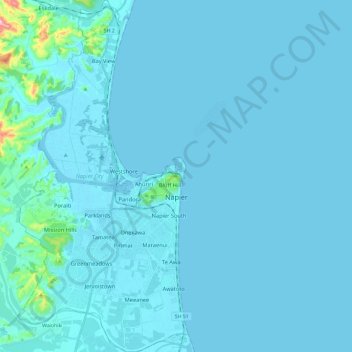
Name: Napier topographic map, elevation, terrain.
Location: Napier, Hawke's Bay, New Zealand (-39.57047 176.81127 -39.38819 176.92593)
Average elevation: 12 m
Minimum elevation: -3 m
Maximum elevation: 276 m
Hawke's Bay trails, hiking, mountain biking, running and outdoor activities
Make a donation
Other topographic maps
Click on a map to view its topography, its elevation and its terrain.
Make a donation
Make a donation
Make a donation
Taumatawhakatangihangakōauauotamateapōkaiwhenuakitānatahu
New Zealand > Hawke's Bay > Central Hawke's Bay District
Average elevation: 199 m
Make a donation
Make a donation
Taumatawhakatangihangakōauauotamateapōkaiwhenuakitānatahu
New Zealand > Hawke's Bay > Central Hawke's Bay District
Average elevation: 199 m
Make a donation
Make a donation