County Carlow topographic map
Interactive map
Click on the map to display elevation.
About this map
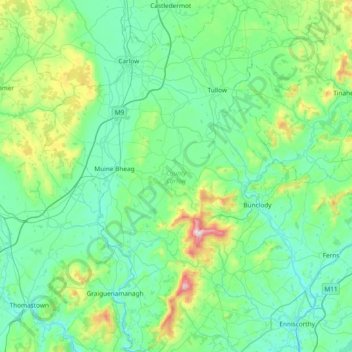
Name: County Carlow topographic map, elevation, terrain.
Location: County Carlow, Leinster, Ireland (52.46359 -7.10794 52.91802 -6.50494)
Average elevation: 126 m
Minimum elevation: 0 m
Maximum elevation: 789 m
The soils of the county are mostly derived from glacial till, rather than solid bedrock geology. These typically consist of a mix of clay, sand and gravel. Occasionally glacial melt-water would form a long ridge of sand and gravel known as an esker. One such example is preserved within the county and is a proposed natural heritage area, referred to as the Ballymoon Esker. The north of the county is generally flat, while central and southern Carlow are characterised by an undulating to rolling topography which becomes progressively hillier towards the south and east. The Blackstairs Mountains are the highest and most extensive upland area, with Mount Leinster rising to 794 m (2,605 ft), making it the highest point in both Carlow and Wexford and the seventh highest county top in Ireland.
Other topographic maps
Click on a map to view its topography, its elevation and its terrain.
Knockgriffin (Imokilly)
Knockgriffin (Imokilly), Midleton Rural, The Municipal District of East Cork, County Cork, Munster, Ireland
Average elevation: 20 m
Corleggy
Corleggy, Grilly ED, Cavan-Belturbet Municipal District, County Cavan, Ulster, Ireland
Average elevation: 52 m
Glencar
Glencar, Kenmare Municipal District, County Kerry, Munster, Ireland
Average elevation: 114 m
Queenstown No 1
Queenstown No 1, Municipal District of Cobh, County Cork, Munster, Ireland
Average elevation: 22 m
Benmore
Benmore, Westport-Belmullet Municipal District, County Mayo, Connacht, Ireland
Average elevation: 119 m
Kilburne
Kilburne, Waterford City Metropolitan District, County Waterford, Munster, X91 HH58, Ireland
Average elevation: 38 m
Cooraclare
Cooraclare, West Clare Municipal District, County Clare, Munster, Ireland
Average elevation: 34 m
Roundstone
Roundstone, Roundstone ED, Conamara Municipal District, County Galway, Connacht, H91 WP99, Ireland
Average elevation: 34 m
Blackstone
Blackstone, Killag ED, The Borough District of Wexford, County Wexford, Leinster, Ireland
Average elevation: 5 m
Lucan
Lucan, South Dublin, County Dublin, Leinster, K78 Y0F1, Ireland
Average elevation: 59 m
Greenlane
Greenlane, Finnoe, The Municipal District of Nenagh, County Tipperary, Munster, Ireland
Average elevation: 60 m
Marian Place
Marian Place, Portlaoise Rural ED, The Municipal District of Portlaoise, County Laois, Leinster, Ireland
Average elevation: 100 m
Tramore
Tramore, Waterford City Metropolitan District, County Waterford, Munster, Ireland
Average elevation: 41 m
The Borough District of Clonmel
The Borough District of Clonmel, County Tipperary, Munster, Ireland
Average elevation: 118 m
Clonmel
Ireland > County Dublin > Dublin
Clonmel, Ballymun E ED, Dublin, County Dublin, Leinster, Ireland
Average elevation: 57 m
Waterford
Ireland > County Waterford > Waterford
Waterford, County Waterford, Munster, Ireland
Average elevation: 33 m
Clonee
Ireland > County Meath > Clonee
Clonee, The Municipal District of Ratoath, County Meath, Leinster, D15 X036, Ireland
Average elevation: 66 m
Fanore
Ireland > County Clare > Fanore
Fanore, West Clare Municipal District, County Clare, Munster, Ireland
Average elevation: 87 m
Rathmore
Rathmore, Kilscoran ED, The Borough District of Wexford, County Wexford, Leinster, Ireland
Average elevation: 21 m
Rapla
Rapla, Nenagh Rural, The Municipal District of Nenagh, County Tipperary, Munster, Ireland
Average elevation: 78 m
Lambay Island
Lambay Island, Donabate ED, Fingal, County Dublin, Leinster, Ireland
Average elevation: 14 m
Ferns
Ireland > County Wexford > Ferns
Ferns, The Municipal District of Enniscorthy, County Wexford, Leinster, Y21 E8D5, Ireland
Average elevation: 60 m
Ballyguyroe South
Ireland > County Cork > Ballyguyroe South
Ballyguyroe South, Farahy, The Municipal District of Fermoy, County Cork, Munster, Ireland
Average elevation: 95 m
Blarney - Macroom
Ireland > County Cork > Blarney - Macroom
Blarney - Macroom, County Cork, Munster, Ireland
Average elevation: 161 m
Great Skellig
Great Skellig, Kenmare Municipal District, County Kerry, Munster, Ireland
Average elevation: 1 m
Galway City
Ireland > Galway City > Galway City
Galway City, County Galway, Connacht, Ireland
Average elevation: 15 m
Innishannon
Innishannon, The Municipal District of Bandon – Kinsale, County Cork, Munster, T12 P27P, Ireland
Average elevation: 56 m
Ballyhooly
Ballyhooly, The Municipal District of Fermoy, County Cork, Munster, Ireland
Average elevation: 123 m
Portmarnock
Portmarnock, Fingal, County Dublin, Leinster, D13 YV05, Ireland
Average elevation: 7 m
Craughwell
Craughwell, Loughrea Municipal District, County Galway, Connacht, Ireland
Average elevation: 30 m
Shankhill-Rathmichael ED
Shankhill-Rathmichael ED, Dún Laoghaire-Rathdown, Dublin 18, Leinster, Ireland
Average elevation: 95 m