
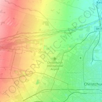
Fendalton-Waimari-Harewood Community topographic map
Interactive map
Click on the map to display elevation.
Fendalton-Waimari-Harewood Community topographic map, elevation, terrain
About this map
Name: Fendalton-Waimari-Harewood Community topographic map, elevation, terrain.
Average elevation: 39 m
Minimum elevation: 0 m
Maximum elevation: 103 m
Other topographic maps
Click on a map to view its topography, its elevation and its terrain.
Port hills
New Zealand > Canterbury > Christchurch City > Linwood-Central-Heathcote Community
Average elevation: 246 m
Banks Peninsula
New Zealand > Canterbury > Christchurch City > Banks Peninsula Community > Pigeon Bay
Average elevation: 277 m
Akaroa
New Zealand > Canterbury > Christchurch City > Banks Peninsula Community
Average elevation: 152 m
Birdlings Flat
New Zealand > Canterbury > Christchurch City > Banks Peninsula Community
Average elevation: 15 m
Duvauchelle
New Zealand > Canterbury > Christchurch City > Banks Peninsula Community
Average elevation: 277 m
Okains Bay
New Zealand > Canterbury > Christchurch City > Banks Peninsula Community
Average elevation: 148 m
Giant Totara tree
New Zealand > Canterbury > Christchurch City > Banks Peninsula Community
Average elevation: 382 m
Le Bons Bay
New Zealand > Canterbury > Christchurch City > Banks Peninsula Community
Average elevation: 244 m
Wainui
New Zealand > Canterbury > Christchurch City > Banks Peninsula Community
Average elevation: 203 m
Governors Bay
New Zealand > Canterbury > Christchurch City > Banks Peninsula Community
Average elevation: 167 m
Lyttelton
New Zealand > Canterbury > Christchurch City > Banks Peninsula Community
Average elevation: 99 m
Ōhinetahi
New Zealand > Canterbury > Christchurch City > Banks Peninsula Community > Governors Bay
Average elevation: 113 m
Bossu
New Zealand > Canterbury > Christchurch City > Banks Peninsula Community
Average elevation: 409 m
Bishops Green
New Zealand > Canterbury > Christchurch City > Halswell-Hornby-Riccarton Community
Average elevation: 17 m
Halswell-Hornby-Riccarton Community
New Zealand > Canterbury > Christchurch City
Average elevation: 49 m
Purple Peak Saddle
New Zealand > Canterbury > Christchurch City > Banks Peninsula Community
Average elevation: 479 m
Little Akaloa
New Zealand > Canterbury > Christchurch City > Banks Peninsula Community
Average elevation: 215 m
Little River
New Zealand > Canterbury > Christchurch City > Banks Peninsula Community
Average elevation: 220 m
Little River
New Zealand > Canterbury > Christchurch City > Banks Peninsula Community > Little River
Average elevation: 150 m
Okuti Valley
New Zealand > Canterbury > Christchurch City > Banks Peninsula Community
Average elevation: 288 m
Linwood-Central-Heathcote Community
New Zealand > Canterbury > Christchurch City > Linwood-Central-Heathcote Community
Average elevation: 55 m
Pigeon Bay
New Zealand > Canterbury > Christchurch City > Banks Peninsula Community
Average elevation: 243 m
Coastal-Burwood Community
New Zealand > Canterbury > Christchurch City > Coastal-Burwood Community
Average elevation: 6 m