
Horneytown topographic map
Interactive map
Click on the map to display elevation.
About this map
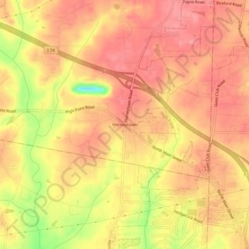
Name: Horneytown topographic map, elevation, terrain.
Average elevation: 268 m
Minimum elevation: 204 m
Maximum elevation: 294 m
Other topographic maps
Click on a map to view its topography, its elevation and its terrain.
Winston-Salem
United States > North Carolina > Forsyth County
Winston-Salem, Forsyth County, North Carolina, United States
Average elevation: 263 m
West Highlands
United States > North Carolina > Forsyth County > Winston-Salem
West Highlands, Winston-Salem, Forsyth County, North Carolina, 27157, United States
Average elevation: 269 m
Ardmore
United States > North Carolina > Forsyth County > Winston-Salem
Ardmore, Winston-Salem, Forsyth County, North Carolina, 27157, United States
Average elevation: 260 m
Briarcliff Manor
United States > North Carolina > Forsyth County > Winston-Salem
Briarcliff Manor, Winston-Salem, Forsyth County, North Carolina, 27103, United States
Average elevation: 248 m
Hampstead
United States > North Carolina > Forsyth County > Hampstead
Hampstead, Forsyth County, North Carolina, 27284, United States
Average elevation: 279 m
Rollingreen
United States > North Carolina > Forsyth County > Clemmons
Rollingreen, Clemmons, Forsyth County, North Carolina, 27012, United States
Average elevation: 237 m
Mallard Lakes
United States > North Carolina > Forsyth County > Winston-Salem
Mallard Lakes, Winston-Salem, Forsyth County, North Carolina, 27010, United States
Average elevation: 267 m
Belews Creek
United States > North Carolina > Forsyth County
Belews Creek, Forsyth County, North Carolina, 27009, United States
Average elevation: 243 m
Stanleyville
United States > North Carolina > Forsyth County > Winston-Salem
Stanleyville, Winston-Salem, Forsyth County, North Carolina, 27045, United States
Average elevation: 271 m
Vienna
United States > North Carolina > Forsyth County > Lewisville
Vienna, Lewisville, Forsyth County, North Carolina, 27040, United States
Average elevation: 261 m
Dozier
United States > North Carolina > Forsyth County > Tobaccoville
Dozier, Tobaccoville, Forsyth County, North Carolina, 27040, United States
Average elevation: 272 m
Seward
United States > North Carolina > Forsyth County
Seward, Forsyth County, North Carolina, 27040, United States
Average elevation: 272 m
Donnaha
United States > North Carolina > Forsyth County
Donnaha, Forsyth County, North Carolina, United States
Average elevation: 259 m
Union Cross
United States > North Carolina > Forsyth County > Winston-Salem
Union Cross, Winston-Salem, Forsyth County, North Carolina, United States
Average elevation: 279 m
Dennis
United States > North Carolina > Forsyth County
Dennis, Forsyth County, North Carolina, United States
Average elevation: 242 m
Yorktown
United States > North Carolina > Forsyth County
Yorktown, Forsyth County, North Carolina, 27285, United States
Average elevation: 279 m
Sherwood Forest
United States > North Carolina > Forsyth County > Lewisville
Sherwood Forest, Lewisville, Forsyth County, North Carolina, 27040, United States
Average elevation: 257 m
Salem Woods
United States > North Carolina > Forsyth County > Winston-Salem
Salem Woods, Winston-Salem, Forsyth County, North Carolina, 27103, United States
Average elevation: 241 m
Pebble Creek Estates
United States > North Carolina > Forsyth County > Winston-Salem
Pebble Creek Estates, Winston-Salem, Forsyth County, North Carolina, United States
Average elevation: 281 m
Clemmons
United States > North Carolina > Forsyth County
Clemmons, Forsyth County, North Carolina, United States
Average elevation: 235 m
Eaglewood
United States > North Carolina > Forsyth County > Lewisville
Eaglewood, Lewisville, Forsyth County, North Carolina, 27023, United States
Average elevation: 261 m
Union Ridge
United States > North Carolina > Forsyth County > Winston-Salem
Union Ridge, Winston-Salem, Forsyth County, North Carolina, 27110, United States
Average elevation: 262 m
Lewisville
United States > North Carolina > Forsyth County
Lewisville, Forsyth County, North Carolina, 27023, United States
Average elevation: 251 m
Kernersville
United States > North Carolina > Forsyth County
Kernersville, Forsyth County, North Carolina, 27284, United States
Average elevation: 283 m
Oak Park
United States > North Carolina > Forsyth County
Oak Park, Forsyth County, North Carolina, 27040, United States
Average elevation: 277 m
Rural Hall
United States > North Carolina > Forsyth County
Rural Hall, Forsyth County, North Carolina, 27045, United States
Average elevation: 282 m
Reynolda Village
United States > North Carolina > Forsyth County > Winston-Salem
Reynolda Village, Winston-Salem, Forsyth County, North Carolina, 27106, United States
Average elevation: 278 m
Salem
United States > North Carolina > Forsyth County > Winston-Salem
Salem, Winston-Salem, Forsyth County, North Carolina, 27110, United States
Average elevation: 256 m
Salem Lake
United States > North Carolina > Forsyth County > Winston-Salem > Woodbridge
Salem Lake, Woodbridge, Winston-Salem, Forsyth County, North Carolina, United States
Average elevation: 264 m
Bethania Station
United States > North Carolina > Forsyth County > Winston-Salem
Bethania Station, Winston-Salem, Forsyth County, North Carolina, 27106, United States
Average elevation: 260 m
Tobaccoville
United States > North Carolina > Forsyth County
Tobaccoville, Forsyth County, North Carolina, United States
Average elevation: 289 m
Old Hollow Estates
United States > North Carolina > Forsyth County > Walkertown > Old Hollow Estates
Old Hollow Estates, Walkertown, Forsyth County, North Carolina, 27051, United States
Average elevation: 286 m
Salem Creek
United States > North Carolina > Forsyth County > Winston-Salem > Salem
Salem Creek, Salem, Winston-Salem, Forsyth County, North Carolina, 27110, United States
Average elevation: 251 m
Lewisville
United States > North Carolina > Forsyth County > Lewisville
Lewisville, Forsyth County, North Carolina, 27023, United States
Average elevation: 251 m
Beeson Crossroads
United States > North Carolina > Forsyth County > Winston-Salem > Beeson Crossroads
Beeson Crossroads, Winston-Salem, Forsyth County, North Carolina, 278284, United States
Average elevation: 284 m
Kimberly Acres
United States > North Carolina > Forsyth County > Kimberly Acres
Kimberly Acres, Forsyth County, North Carolina, 27284, United States
Average elevation: 277 m
Bethania
United States > North Carolina > Forsyth County
Bethania, Forsyth County, North Carolina, 27010, United States
Average elevation: 258 m