
Boyacá topographic map
Interactive map
Click on the map to display elevation.
Boyacá
The department of Boyacá covers a small portion of the Middle Magdalena valley of the Magdalena River to the west, the Cordillera Oriental mountain range with altitudes of 5,380 m above sea level (Sierra Nevada del Cocuy with 25 snow peaks), flat highland plateaux, and another small portion of territory by the eastern Llanos plains. Among its most prominent geographical features are the Range of the Zorro, Serrania de las Quinchas and the Andean plateaus of Rusia, Guantivá, Pisba, Chontales and Rechiniga.
About this map
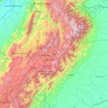
Name: Boyacá topographic map, elevation, terrain.
Location: Boyacá, RAP (Especial) Central, Colombia (4.65581 -74.65933 7.05484 -71.94333)
Average elevation: 1,402 m
Minimum elevation: 62 m
Maximum elevation: 5,125 m
Other topographic maps
Click on a map to view its topography, its elevation and its terrain.
Manizales
Manizales is the capital city of one of the smallest Colombian departments. The city is described as having an "abrupt topography", and lies on the Colombian Central Mountain Range (part of the longest continental mountain range, the Andes), with a great deal of ridgelines and steep slopes, which, combined…
Average elevation: 2,114 m
Pitalito
The valley itself lies at about 1,300 meters above sea level. All the surrounding mountains grow coffee with the average farm having about 6 hectares and about 5,000 trees per hectare. The soil is volcanic, providing plenty of organic nutrients for the high altitude coffee.
Average elevation: 1,635 m
Bogota, Capital District
Bogotá is located in the southeastern part of the Bogotá savanna (Sabana de Bogotá) at an average altitude of 2,640 meters (8,660 ft) above sea level. The Bogotá savanna is popularly called "savannah" (sabana), but constitutes actually a high plateau in the Andes mountains, part of an extended region known…
Average elevation: 2,183 m
Manizales
Manizales is the capital city of one of the smallest Colombian departments. The city is described as having an "abrupt topography", and lies on the Colombian Central Mountain Range (part of the longest continental mountain range, the Andes), with a great deal of ridgelines and steep slopes, which, combined…
Average elevation: 1,933 m
Bogota Capital District - Municipality
Bogotá is located in the southeastern part of the Bogotá savanna (Sabana de Bogotá) at an average altitude of 2,640 meters (8,660 ft) above sea level. The Bogotá savanna is popularly called "savannah" (sabana), but constitutes actually a high plateau in the Andes mountains, part of an extended region known…
Average elevation: 2,183 m
Floridablanca
Floridablanca (Spanish pronunciation: [floˌɾiðaˈβlaŋka], locally also simply Florida) is a municipality in the department of Santander at an altitude of 925 metres (3,035 ft) in the Eastern Ranges of the Colombian Andes. It is part of the metropolitan area of the departmental capital Bucaramanga.…
Average elevation: 1,261 m
Perímetro Urbano Cúcuta
The city is in the eastern part of the Department of North Santander, in the Cordillera Oriental, close to the border with Venezuela. The city's area is 110 square kilometres (42 square miles) and its elevation is 320 metres (1,050 feet) above sea level.
Average elevation: 314 m
Armenia
Armenia has a territorial area of 29,743 square kilometres (11,484 sq mi). The terrain is mostly mountainous, with fast flowing rivers, and few forests. The land rises to 4,090 metres (13,419 feet) above sea level at Mount Aragats, and no point is below 390 metres (1,280 ft) above sea level. Average elevation…
Average elevation: 1,709 m
Cali
Colombia > Valle del Cauca > Cali
Under Köppen's climate classification, Cali features a dry-summer tropical monsoon climate (Köppen climate classification: Am), bordering a tropical savanna climate (Köppen: As). The Western Mountain Range rises from an average of 2,000 m (6,562 ft) above sea level in the northern part of the city to…
Average elevation: 1,071 m
Medellín
Medellín has 16 comunas (districts), 5 corregimientos (townships), and 271 barrios (neighborhoods). The metropolitan area of Medellín lies within the Aburrá valley at an elevation of 1,500 metres (4,900 feet) above sea level and is bisected by the Medellín River (also called Porce), which flows northward.…
Average elevation: 2,071 m