Geolocate

New Caledonia topographic map

Interactive map

Click on the map to display elevation.

New Caledonia

The Diahot River is the longest river of New Caledonia, flowing for some 100 kilometres (62 mi). It has a catchment area of 620 km2 (240 sq mi) and opens north-westward into the Baie d'Harcourt, flowing towards the northern point of the island along the western escarpment of the Mount Panié. Most of the island is covered by wet evergreen forests, while savannahs dominate the lower elevations. The New Caledonian lagoon, with a total area of 24,000 square kilometres (9,300 sq mi) is one of the largest lagoons in the world. The lagoon and the surrounding New Caledonia Barrier Reef was named a UNESCO World Heritage Site in 2008 for its exceptional beauty and marine biodiversity.

Wikipedia (CC-BY-SA 3.0)

About this map

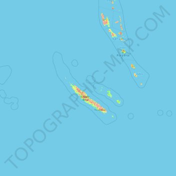
Name: New Caledonia topographic map, elevation, terrain.

Location: New Caledonia, France (-23.22175 157.98475 -17.68686 172.30572)

Average elevation: 4 m

Minimum elevation: 0 m

Maximum elevation: 1,380 m

Other topographic maps

Click on a map to view its topography, its elevation and its terrain.

Calvados

France > Normandy

Average elevation: 117 m

Kermadec

France > Brittany > Morbihan > Inzinzac-Lochrist

Average elevation: 57 m

Winter Peters Etzel

France > Grand Est > Moselle > Rémering

Average elevation: 285 m

Mater Deï

France > Occitania > Aude > Alaigne

Average elevation: 349 m

Laval

France > Pays de la Loire > Mayenne

Elevation varies between 42 and 122 meters above sea level. Laval is, in fact, a hilly town, marked by a rocky promontory dominating the valley of the Mayenne river. The castle was built on this promontory and the medieval centre spreads around. The promontory and the slightly hilly landscape around Laval are…

Average elevation: 87 m

Lichtenberg

France > Grand Est > Bas-Rhin

Average elevation: 279 m

Gordes

France > Provence-Alpes-Côte d'Azur > Vaucluse

Average elevation: 304 m

Aiguebelle

France > Auvergne-Rhône-Alpes > Savoy > Val-d'Arc

Average elevation: 580 m

Champougny

France > Grand Est > Meuse

Average elevation: 285 m

Mende

France > Occitania > Lozère

Average elevation: 976 m

Nevet

France > Brittany > Finistère > Laz

Average elevation: 185 m

Mars

France > Auvergne-Rhône-Alpes > Ardèche

Average elevation: 1,029 m

Reims

France > Grand Est > Marne

Average elevation: 96 m

Stosswihr

France > Grand Est > Haut-Rhin

Average elevation: 708 m

Pornic

France > Pays de la Loire > Loire-Atlantique

Average elevation: 15 m

Plonéour-Lanvern

France > Brittany > Finistère

Average elevation: 38 m

Aiguillon

France > Nouvelle-Aquitaine > Lot-et-Garonne

Average elevation: 54 m

Nantes

France > Pays de la Loire > Loire-Atlantique

Nantes is built on the Armorican Massif, a range of weathered mountains which may be considered the backbone of Brittany. The mountains, stretching from the end of the Breton peninsula to the outskirts of the sedimentary Paris Basin, are composed of several parallel ridges of Ordovician and Cadomian rocks.…

Average elevation: 26 m

Amboise

France > Centre-Val de Loire > Indre-et-Loire

Average elevation: 91 m

Mhère

France > Bourgogne – Franche-Comté > Nièvre

Average elevation: 364 m

Saint-Léger

France > Hauts-de-France > Pas-de-Calais

Average elevation: 99 m

Aisne

France > Hauts-de-France

Average elevation: 133 m

Metzing

France > Grand Est > Moselle

Average elevation: 251 m

Berg-sur-Moselle

France > Grand Est > Moselle

Average elevation: 168 m

9th Arrondissement

France > Ile-de-France > Paris

Average elevation: 60 m

Paris

France > Ile-de-France

Average elevation: 59 m

4th Arrondissement

France > Ile-de-France > Paris

Average elevation: 47 m

1st Arrondissement

France > Ile-de-France > Paris

Average elevation: 46 m

10th Arrondissement

France > Ile-de-France > Paris

Average elevation: 59 m

3rd Arrondissement

France > Ile-de-France > Paris

Average elevation: 49 m

2nd Arrondissement

France > Ile-de-France > Paris

Average elevation: 49 m

18th Arrondissement

France > Ile-de-France > Paris

Average elevation: 59 m

Noumea

France > South Province

Average elevation: 8 m

Epping

France > Grand Est > Moselle

Average elevation: 307 m

Saint-Denis

France > Réunion

The city is located on the north end of the island, and was a port. Saint-Denis was "originally the main port of Réunion, but an artificial harbour at Le Port, on the northwest coast, replaced it in the 1880s, because of unpredictable winds and tides at Saint-Denis." The city includes some of the island's…

Average elevation: 722 m

Lifou

France > Loyalty Islands Province

Average elevation: 16 m