
Make a donation
San Juan topographic map
Click on the map to display elevation.
Make a donation
San Juan
As with other parts of Puerto Rico and the Caribbean, San Juan is often blanketed by waves of Saharan dust coming from the Sahara across the Atlantic Ocean in Northern Africa. Although beneficial to the tropical environment, these dust storms have recently become hazardous to human health causing haze and overheating in urban areas of the island. Due to San Juan's relatively flat geography, the dust often settles in these flat coastal regions of Puerto Rico as its flow is blocked by the higher altitude Cordillera Central to the south, causing intense episodes of haze to settle for long periods of time, especially during periods of more scarce rainfall. Recent advancements include early warning systems to prepare the population for these intense episodes by both local authorities and the EPA.
Make a donation
About this map
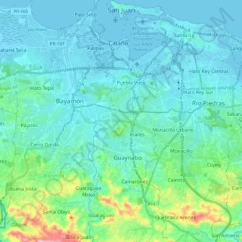
Name: San Juan topographic map, elevation, terrain.
Location: San Juan, Puerto Rico, United States (18.29653 -66.12509 18.47199 -65.99142)
Average elevation: 59 m
Minimum elevation: -3 m
Maximum elevation: 400 m
Make a donation
Other topographic maps
Click on a map to view its topography, its elevation and its terrain.
Make a donation
Ceiba
United States > Puerto Rico > Ceiba
The highest point in the municipality is Pico del Oeste in the Sierra de Luquillo at 3,346 feet (1,020 m) of elevation.
Average elevation: 50 m
Make a donation
Make a donation
Make a donation
Make a donation
Make a donation
Make a donation
Make a donation
Gozalandia Waterfall
United States > Puerto Rico > San Sebastián > San Sebastián
Average elevation: 176 m
Make a donation
Make a donation
Make a donation
Make a donation
Mayagüez
United States > Puerto Rico > Mayagüez
Mayagüez has a tropical monsoon climate (Köppen climate classification Am). The city has the most extreme weather of the island. The high frequency of severe storms in the summer can produce strong winds, floods, waterspouts, and sometimes hail and even tornadoes. The average annual temperature is 75 °F (24…
Average elevation: 93 m
Cerro de Punta
United States > Puerto Rico > Ponce
The mountain is part of the Cordillera Central and is located on the border between the municipalities of Jayuya and Ponce. The access road to the point closest to the highest elevation is from the municipality of Jayuya. It is part of the Toro Negro Forest Reserve, and it has been described as "an alpine…
Average elevation: 1,021 m
Isla de Mona
United States > Puerto Rico > Mayagüez
Mona is a mainly flat plateau surrounded by sea cliffs. It is composed of dolomite and limestone with many caves found throughout. With an arid climate and untouched by human development, many endemic species inhabit the island, such as the Mona ground iguana (Cyclura cornuta stejnegeri). Its topography,…
Average elevation: 26 m
Make a donation
Cayey
United States > Puerto Rico > Cayey
Cayey's climate is humid, rainy and mild compared to lower-elevation areas of the island, the area of the town is nearly 1,500 feet (460 m) high, so the climate is subtropical high. In summer average high Temperatures are around 82 °F to 88 °F and 70 °F to 78 °F in winter, and low around 68 °F to 72 °F…
Average elevation: 489 m
Make a donation
Make a donation
Villalba
United States > Puerto Rico > Villalba > Villalba
Villalba is located in the central region of Puerto Rico, on a valley in the Cordillera Central. The highest point in the municipality is Cerro El Bolo at 3,526 feet (1,075 m) of elevation.
Average elevation: 406 m
Make a donation
Make a donation
Make a donation
Make a donation
Make a donation