
Thank you for supporting this site ❤️
Make a donation
Make a donation
Casa Grande topographic map
Click on the map to display elevation.
Thank you for supporting this site ❤️
Make a donation
Make a donation
About this map
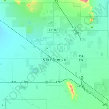
Name: Casa Grande topographic map, elevation, terrain.
Location: Casa Grande, Pinal County, Arizona, United States (32.77750 -111.91231 32.99662 -111.63653)
Average elevation: 439 m
Minimum elevation: 394 m
Maximum elevation: 822 m
Thank you for supporting this site ❤️
Make a donation
Make a donation
Other topographic maps
Click on a map to view its topography, its elevation and its terrain.
Heaton
United States > Arizona > Pinal County > Maricopa
Heaton is a populated place situated in Pinal County, Arizona, United States. It has an estimated elevation of 1,197 feet (365 m) above sea level.
Average elevation: 367 m