
Make a donation
Adamawa State topographic map
Click on the map to display elevation.
Make a donation
Adamawa State
Topographically, it is a mountainous land crossed by the large river valleys – Benue, Gongola and Yedsarem. The valleys of the Mount Cameroon, Mandara Mountains and Adamawa Plateau form part of the landscape.
Make a donation
About this map
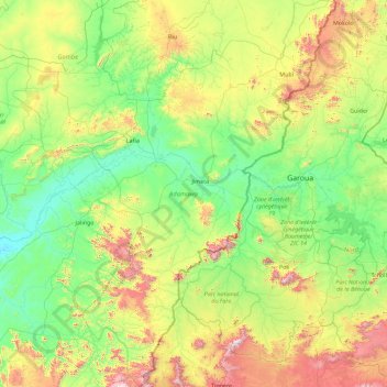
Name: Adamawa State topographic map, elevation, terrain.
Location: Adamawa State, Nigeria (7.35837 11.34152 10.94946 13.72955)
Average elevation: 452 m
Minimum elevation: 105 m
Maximum elevation: 1,949 m
Make a donation
Other topographic maps
Click on a map to view its topography, its elevation and its terrain.
Make a donation
Jos
Nigeria > Plateau State > Jos North
At an altitude of 1,217 m (3,993 ft) above sea level, Jos' climate is closer to temperate than that of the vast majority of Nigeria. Average monthly temperatures range from 21–25 °C (70–77 °F), and from mid-November to late January, night-time temperatures drop as low as 7 °C (45 °F). Hail sometimes…
Average elevation: 1,181 m
Make a donation
Make a donation