
Make a donation
Marion County topographic map
Click on the map to display elevation.
Make a donation
Marion County
Marion County is generally composed of rolling hills, much like most of the rest of Florida. The highest elevation is about 60 meters (200 feet). The majority of its trees consist of live oaks, pines, and palm trees.
Make a donation
About this map
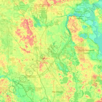
Name: Marion County topographic map, elevation, terrain.
Location: Marion County, Florida, United States (28.95980 -82.53595 29.52168 -81.63893)
Average elevation: 24 m
Minimum elevation: 0 m
Maximum elevation: 70 m
Make a donation
Other topographic maps
Click on a map to view its topography, its elevation and its terrain.
Make a donation
Make a donation
Make a donation
Make a donation
Lealman
United States > Florida > Pinellas County
Lealman is located at 27°49′10″N 82°41′4″W / 27.81944°N 82.68444°W / 27.81944; -82.68444 (27.8197, -82.6846). The community is bordered by the city of Pinellas Park to the north, St. Petersburg to the east and south, and by the town of West Lealman to the west. The elevation is 49 feet (15…
Average elevation: 13 m
Make a donation
Make a donation
Make a donation