
Thank you for supporting this site ❤️
Make a donation
Make a donation
Leatham River topographic map
Click on the map to display elevation.
Thank you for supporting this site ❤️
Make a donation
Make a donation
About this map
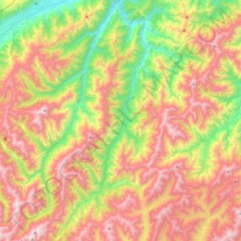
Name: Leatham River topographic map, elevation, terrain.
Location: Leatham River, Marlborough, New Zealand (-41.98902 173.05895 -41.72040 173.20722)
Average elevation: 1,234 m
Minimum elevation: 405 m
Maximum elevation: 2,157 m
Marlborough trails, hiking, mountain biking, running and outdoor activities
Thank you for supporting this site ❤️
Make a donation
Make a donation
Other topographic maps
Click on a map to view its topography, its elevation and its terrain.
Thank you for supporting this site ❤️
Make a donation
Make a donation
Thank you for supporting this site ❤️
Make a donation
Make a donation