
Thank you for supporting this site ❤️
Make a donation
Make a donation
Southern Highlands topographic map
Click on the map to display elevation.
Thank you for supporting this site ❤️
Make a donation
Make a donation
About this map
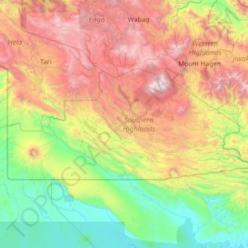
Name: Southern Highlands topographic map, elevation, terrain.
Location: Southern Highlands, Highlands Region, Papua New Guinea (-6.82364 142.62552 -5.90273 144.69489)
Average elevation: 1,245 m
Minimum elevation: -1 m
Maximum elevation: 4,250 m
Thank you for supporting this site ❤️
Make a donation
Make a donation
Other topographic maps
Click on a map to view its topography, its elevation and its terrain.
Mount Hagen
Papua New Guinea > Western Highlands > Mount Hagen District
Mount Hagen (Tok Pisin: Maun Hagen) is the third largest city in Papua New Guinea, with a population of 46,250. It is the capital of the Western Highlands Province and is located in the large fertile Wahgi Valley in central mainland Papua New Guinea, at an elevation of 1,677 m (5,502 ft).
Average elevation: 1,904 m
Thank you for supporting this site ❤️
Make a donation
Make a donation
Thank you for supporting this site ❤️
Make a donation
Make a donation