
Kodagu topographic map
Interactive map
Click on the map to display elevation.
About this map
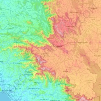
Name: Kodagu topographic map, elevation, terrain.
Location: Kodagu, Karnataka, India (11.93123 75.36544 12.83349 76.18857)
Average elevation: 561 m
Minimum elevation: -3 m
Maximum elevation: 1,713 m
Kodagu is located on the eastern slopes of the Western Ghats. It has a geographical area of 4,102 km2 (1,584 sq mi). The district is bordered by Dakshina Kannada district to the northwest, Hassan district to the north, Mysore district to the east, Kasaragod district in west and Kannur district of Kerala to the southwest, and Wayanad district of Kerala to the south. It is a hilly district, the lowest elevation of which is 120 metres (390 ft) above sea-level. The highest peak, Tadiandamol, rises to 1,750 metres (5,740 ft), with Pushpagiri, the second highest, at 1,715 metres (5,627 ft). The main river in Kodagu is the Kaveri (Cauvery), which originates at Talakaveri, located on the eastern side of the Western Ghats, and with its tributaries, drains the greater part of Kodagu.
Other topographic maps
Click on a map to view its topography, its elevation and its terrain.
Bangalore South
Bangalore South, Bengaluru Urban, Karnataka, India
Average elevation: 847 m
Bengaluru
India > Karnataka > Bangalore North
Bengaluru, Bangalore North, Bangalore Urban, Karnataka, India
Average elevation: 881 m
Naruru
India > Karnataka > Shirasi taluk
Naruru, Shirasi taluk, Uttara Kannada, Karnataka, 581318, India
Average elevation: 568 m
Harihara
India > Karnataka > Harihara taluku > Harihara
Harihara, Harihara taluku, Davanagere district, Karnataka, 577600, India
Average elevation: 545 m
Kalaburagi
Kalaburagi, Kalaburagi district, Karnataka, India
Average elevation: 489 m
Hegganahalli
Hegganahalli, Dasarahalli Zone, Bengaluru, Bangalore Urban, Karnataka, India
Average elevation: 907 m
Jnana Bharathi
Jnana Bharathi, Rajarajeshwari Nagar Zone, Bengaluru, Bangalore Urban, Karnataka, India
Average elevation: 850 m
Krishna River
Krishna River, Shahapura taluku, Yadagiri district, Karnataka, 412803, India
Average elevation: 413 m
Kumara Parvatha
Kumara Parvatha, Somawarpet taluk, Kodagu, Karnataka, India
Average elevation: 1,227 m
Chikmagalur
Chikmagalur, Chikkamagaluru district, Karnataka, India
Average elevation: 652 m
Baba Budangiri
India > Karnataka > Chikkamagaluru
Baba Budangiri, Chikkamagaluru, Chikkamagaluru taluku, Chikkamagaluru district, Karnataka, 577101, India
Average elevation: 1,628 m
Tadiandamol
Tadiandamol, Madikeri taluku, Kodagu, Karnataka, India
Average elevation: 1,322 m