
Lomami topographic map
Interactive map
Click on the map to display elevation.
About this map
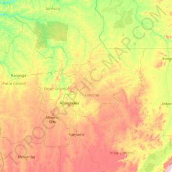
Name: Lomami topographic map, elevation, terrain.
Location: Lomami, Democratic Republic of the Congo (-8.72866 21.85780 -3.52866 27.05780)
Average elevation: 712 m
Minimum elevation: 374 m
Maximum elevation: 1,824 m
Other topographic maps
Click on a map to view its topography, its elevation and its terrain.
Nkonga
Democratic Republic of the Congo > Kasai-Oriental > Ville de Mbujimayi
Average elevation: 608 m
Lake Edward
Democratic Republic of the Congo > North Kivu > Lubero
Lake Edward lies at an elevation of 920 metres (3,020 ft), is 77 kilometres (48 mi) long by 40 kilometres (25 mi) wide at its maximum points, and covers a total surface area of 2,325 square kilometres (898 sq mi), making it the 15th-largest on the continent. The lake is fed by the Nyamugasani River, the…
Average elevation: 1,132 m