
Katanga topographic map
Interactive map
Click on the map to display elevation.
About this map
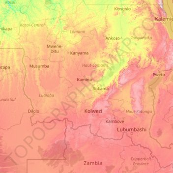
Name: Katanga topographic map, elevation, terrain.
Location: Katanga, Democratic Republic of the Congo (-13.45904 21.75076 -4.99994 30.79625)
Average elevation: 1,008 m
Minimum elevation: 386 m
Maximum elevation: 2,546 m
Other topographic maps
Click on a map to view its topography, its elevation and its terrain.
Nkonga
Democratic Republic of the Congo > Kasai-Oriental > Ville de Mbujimayi
Average elevation: 608 m
Lake Edward
Democratic Republic of the Congo > North Kivu > Lubero
Lake Edward lies at an elevation of 920 metres (3,020 ft), is 77 kilometres (48 mi) long by 40 kilometres (25 mi) wide at its maximum points, and covers a total surface area of 2,325 square kilometres (898 sq mi), making it the 15th-largest on the continent. The lake is fed by the Nyamugasani River, the…
Average elevation: 1,132 m
Kinshasa
Democratic Republic of the Congo > Kinshasa
Geographically covering 9,965 square kilometers, Kinshasa stretches along the southern shores of the Pool Malebo, forming an expansive crescent across flat, low-lying terrain at an average altitude of about 300 meters. Situated between latitudes 4° and 5° and longitudes East 15° and 16°32, Kinshasa shares…
Average elevation: 316 m