
Guanajuato topographic map
Interactive map
Click on the map to display elevation.
About this map
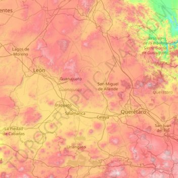
Name: Guanajuato topographic map, elevation, terrain.
Location: Guanajuato, Mexico (19.91275 -102.09728 21.83942 -99.67130)
Average elevation: 2,005 m
Minimum elevation: 873 m
Maximum elevation: 3,508 m
Guanajuato is in the center of Mexico, northwest of Mexico City, bordering Zacatecas, San Luis Potosí, Michoacán, Querétaro, and Jalisco. It is the 20th-largest of Mexico's states, with an area of 30,589 km². It has an average altitude of 2,015 meters (6,611 ft) above sea level, with its territory divided among three of Mexico's physical regions, the Sierra Madre Oriental, the Mexican Plateau and the Trans-Mexican Volcanic Belt. The Sierra Madre Oriental in Guanajuato consists of the Sierra Gorda and the Sierra del Azafrán in the northeast. The Mexican Plateau extends through the center of the state. It is subdivided into various regions parted by low-lying mountain chains such as the Sierra de la Cuatralba and the Sierra de Cubo. The Trans Mexican Volcanic Belt crosses the state in the south and includes the Bajío area, the Altos de Jalisco and the valleys area in the far south. The state is crossed by several mountain ranges with mountains between 2,300 and 3,000 meters high. Mountain ranges average 2,305 meters and flat areas lie at around 1,725 meters above mean sea level. Other important mountain ranges include the Sierra Gorda to the north, the Sierra de Guanajuato in the southeast, the Comanja in the northwest and the Codorniz in the east.
Other topographic maps
Click on a map to view its topography, its elevation and its terrain.
Chalchicomula de Sesma
Chalchicomula de Sesma, Puebla, 75520, Mexico
Average elevation: 2,638 m
Santa María Yalina
Mexico > Oaxaca > Santa María Yalina
Santa María Yalina, Oaxaca, Mexico
Average elevation: 1,808 m
Jalpan de Serra
Mexico > Querétaro > Jalpan de Serra
Jalpan de Serra, Querétaro, 76340, Mexico
Average elevation: 805 m
Venustiano Carranza
Mexico > Veracruz > Xalapa > Xalapa
Venustiano Carranza, Xalapa, Veracruz, 91090, Mexico
Average elevation: 1,370 m
Temascaltepec de González
Temascaltepec de González, Temascaltepec, Mexico
Average elevation: 1,873 m
Tehuastepec (San José Tehuastepec)
Tehuastepec (San José Tehuastepec), Valle de Bravo, Mexico
Average elevation: 2,241 m
Ahualulco
Mexico > San Luis Potosi > Ahualulco
Ahualulco, San Luis Potosi, Mexico
Average elevation: 1,901 m
San Agustín
Mexico > Jalisco > Tlajomulco de Zuñiga
San Agustín, Tlajomulco de Zuñiga, Jalisco, 45645, Mexico
Average elevation: 1,646 m
Colonia Santa Isabel
Mexico > Veracruz > Tihuatlán > Plan de Ayala
Colonia Santa Isabel, Plan de Ayala, Terrenos del Lote "San Miguel Mecatepec", Tihuatlán, Veracruz, 93327, Mexico
Average elevation: 77 m
San Juan la Unión
Mexico > Oaxaca > San Lucas Zoquiápam
San Juan la Unión, San Lucas Zoquiápam, Oaxaca, Mexico
Average elevation: 1,750 m
Guadalupe Victoria
Mexico > San Luis Potosi > Tancanhuitz
Guadalupe Victoria, Tancanhuitz, San Luis Potosi, Mexico
Average elevation: 192 m
Puerto San Andrés
Mexico > Nuevo León > General Zaragoza
Puerto San Andrés, General Zaragoza, Nuevo León, Mexico
Average elevation: 3,170 m
Palos Verdes
Palos Verdes, Mocorito, Sinaloa, Mexico
Average elevation: 103 m
Ecatepec de Morelos
Mexico > State of Mexico > Ecatepec de Morelos
Ecatepec de Morelos, State of Mexico, Mexico
Average elevation: 2,296 m
Valle de Bravo
Valle de Bravo, State of Mexico, Mexico
Average elevation: 2,072 m
Puerto Vallarta
Mexico > Jalisco > Puerto Vallarta
Puerto Vallarta, Jalisco, 48300, Mexico
Average elevation: 306 m
Mexico City
Mexico > Mexico City > Mexico City
Mexico City, Cuauhtémoc, Mexico City, 06060, Mexico
Average elevation: 2,321 m
Ensenada
Mexico > Baja California > Ensenada
Ensenada, Baja California, Mexico
Average elevation: 184 m
Guadalajara
Mexico > Jalisco > Guadalajara
Guadalajara, Jalisco, 44360, Mexico
Average elevation: 1,572 m
Mexicali
Mexico > Baja California > Mexicali
Mexicali, Baja California, 21000, Mexico
Average elevation: 18 m
Rincon de Guayabitos
Mexico > Nayarit > Rincon de Guayabitos
Rincon de Guayabitos, Compostela, Nayarit, 63727, Mexico
Average elevation: 30 m
Santa Catarina
Mexico > Nuevo León > Santa Catarina
Santa Catarina, Nuevo León, 66350, Mexico
Average elevation: 842 m