
Make a donation
Guerrero topographic map
Click on the map to display elevation.
Make a donation
Guerrero
The state's climate is dominated by the rainy tropical areas and rainy temperate areas. The former has high temperatures above 18 °C (64.4 °F) year round and experiences most rain in the summer and early fall. Most of this is found near the coast under 2,000 m (6,562 ft) asl. In the higher elevations away from the coast in the Sierra Madre del Sur, the climate is temperate but also experiences the same pattern of rainfall. Most of the rain that falls in the state is produced from evaporation from the Pacific Ocean.
Make a donation
About this map
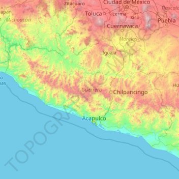
Name: Guerrero topographic map, elevation, terrain.
Location: Guerrero, Mexico (16.31622 -102.18435 18.88785 -98.00728)
Average elevation: 862 m
Minimum elevation: -1 m
Maximum elevation: 5,195 m
Make a donation
Other topographic maps
Click on a map to view its topography, its elevation and its terrain.
Make a donation
Tecate
Mexico > Baja California > Municipio de Tecate
Tecate's altitude of approximately 540 m (1,770 ft) above sea level and its proximity to the ocean contribute to the temperate climate. It rains enough in the area (almost 360 mm [14 in] per year) for a thick ground cover of shrubs and scattered trees to grow.
Average elevation: 595 m
Make a donation
Hermosillo
Mexico > Sonora > Hermosillo
The Cerro de la Campana mountain is one of the symbols of Hermosillo. Its summit is 350 metres (1,150 ft) above the valley floor and contains a lookout called El Caracol, which was inaugurated in 1909. There are two theories as to the origin of the mountain's name. One states that it is from a peculiar…
Average elevation: 248 m
Make a donation
Sombrerete
Mexico > Zacatecas > Sombrerete
The region is between the Sierra Madre Occidental and the central highlands of Mexico. The municipality is in a valley is surrounded on all sides by small mountain ranges such as the Sierra de Sombrerete and the Sierra de Santa María with prominent elevations such as the Cerro Grande, Cerro Reyes, Cerro…
Average elevation: 2,401 m
Make a donation
San Luis Potosí City
Mexico > San Luis Potosi > Municipio de San Luis Potosí
San Luis Potosí, commonly referred to as San Luis, or by its initials SLP (Otomi: Nmiñ'u), is the capital and the most populous city of the Mexican state of San Luis Potosí. It is the municipal seat of the surrounding municipality of San Luis Potosí. The city lies at an elevation of 1,864 metres (6,115…
Average elevation: 2,004 m
Make a donation
Make a donation
Make a donation