
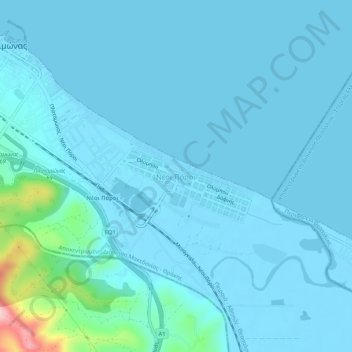
Nei Pori topographic map
Interactive map
Click on the map to display elevation.
About this map
Name: Nei Pori topographic map, elevation, terrain.
Average elevation: 16 m
Minimum elevation: -4 m
Maximum elevation: 189 m
Der touristisch geprägte Hauptort Nei Pori liegt zwischen der Bahnlinie der OSE im Süden und dem Thermaischen Golf. Die Bebauung geht im Nordwesten ohne erkennbare Grenze in das angrenzende Platamonas über. Etwa 1,5 km im Hinterland von Platamonas liegt südlich der Nationalstraße 1 Agios Dimitrios, der alte Ort Pori etwa 5,5 km westlich auf etwa 500 m Höhe.
Other topographic maps
Click on a map to view its topography, its elevation and its terrain.
Λιτόχωρο
Griechenland > Makedonien - Thrakien > Regionalbezirk Pieria
Λιτόχωρο, Δήμος Δίου - Ολύμπου, Regionalbezirk Pieria, Zentralmakedonien, Makedonien - Thrakien, 602 00, Griechenland
Average elevation: 396 m
Platamonas
Griechenland > Makedonien - Thrakien > Regionalbezirk Pieria
Platamonas, Δήμος Δίου - Ολύμπου, Regionalbezirk Pieria, Zentralmakedonien, Makedonien - Thrakien, 600 65, Griechenland
Average elevation: 109 m