
Λιτόχωρο topographic map
Interactive map
Click on the map to display elevation.
About this map
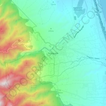
Name: Λιτόχωρο topographic map, elevation, terrain.
Average elevation: 396 m
Minimum elevation: 0 m
Maximum elevation: 1,460 m
Das im Wiederaufbau befindliche Kloster Agios Dionysios, in 850 m Höhe am europäischen Fernwanderweg E4 gelegen. Es liegt rund 15 km oberhalb von Litochoro. Das Kloster wurde von deutschen Truppen bombardiert und im April 1943 gesprengt.
Other topographic maps
Click on a map to view its topography, its elevation and its terrain.
Platamonas
Griechenland > Makedonien - Thrakien > Regionalbezirk Pieria
Platamonas, Δήμος Δίου - Ολύμπου, Regionalbezirk Pieria, Zentralmakedonien, Makedonien - Thrakien, 600 65, Griechenland
Average elevation: 109 m
Nei Pori
Griechenland > Makedonien - Thrakien > Regionalbezirk Pieria
Nei Pori, Δήμος Δίου - Ολύμπου, Regionalbezirk Pieria, Zentralmakedonien, Makedonien - Thrakien, 600 65, Griechenland
Average elevation: 16 m