
Platamonas topographic map
Interactive map
Click on the map to display elevation.
About this map
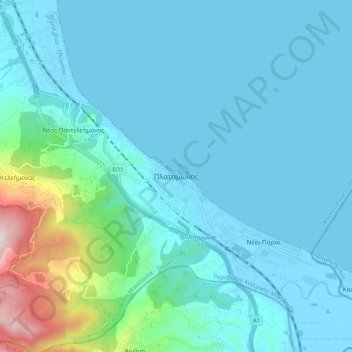
Name: Platamonas topographic map, elevation, terrain.
Average elevation: 109 m
Minimum elevation: -4 m
Maximum elevation: 820 m
Other topographic maps
Click on a map to view its topography, its elevation and its terrain.
Λιτόχωρο
Griechenland > Makedonien - Thrakien > Regionalbezirk Pieria
Λιτόχωρο, Δήμος Δίου - Ολύμπου, Regionalbezirk Pieria, Zentralmakedonien, Makedonien - Thrakien, 602 00, Griechenland
Average elevation: 396 m
Nei Pori
Griechenland > Makedonien - Thrakien > Regionalbezirk Pieria
Nei Pori, Δήμος Δίου - Ολύμπου, Regionalbezirk Pieria, Zentralmakedonien, Makedonien - Thrakien, 600 65, Griechenland
Average elevation: 16 m