
Make a donation
Breede Valley Local Municipality topographic map
Click on the map to display elevation.
Make a donation
About this map
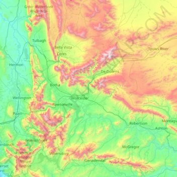
Name: Breede Valley Local Municipality topographic map, elevation, terrain.
Average elevation: 627 m
Minimum elevation: 12 m
Maximum elevation: 2,223 m
Make a donation
Other topographic maps
Click on a map to view its topography, its elevation and its terrain.
Chaos
South Africa > Western Cape > Cape Winelands District Municipality > Witzenberg Local Municipality
Average elevation: 1,346 m
Wellington
South Africa > Western Cape > Cape Winelands District Municipality > Drakenstein Local Municipality
Stretching for approximately 18 kilometers (11 miles), the pass rises to an altitude of 595 meters (1,952 feet) at its highest point. It winds through rugged mountains, offering spectacular vistas of the surrounding valleys, rivers, and fynbos-covered landscapes. The route is popular with tourists, cyclists,…
Average elevation: 168 m
Worcester
South Africa > Western Cape > Cape Winelands District Municipality > Breede Valley Local Municipality
Worcester is located at an elevation of 220 metres (720 ft) and can be reached by road either travelling on the N1 highway through the Huguenot Tunnel or by driving through spectacular mountain passes. From Cape Town Du Toitskloof, from Wellington Bainskloof, from Malmesbury, Western Cape Nieuwekloof, from…
Average elevation: 252 m
Stellenbosch
South Africa > Western Cape > Cape Winelands District Municipality > Stellenbosch Local Municipality
Stellenbosch is 53 km (33 mi) east of Cape Town via National Route N1. Stellenbosch is in a hilly region of the Cape Winelands, and is sheltered in a valley at an average elevation of 136 m (446 ft), flanked on the west by Papegaaiberg (Afrikaans: Parrot Mountain), which is actually a hill. To the south is…
Average elevation: 287 m
Make a donation