
Harlech topographic map
Interactive map
Click on the map to display elevation.
About this map
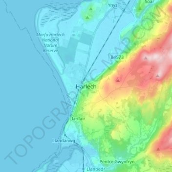
Name: Harlech topographic map, elevation, terrain.
Location: Harlech, Gwynedd, Wales, LL46 2SG, United Kingdom (52.81877 -4.14745 52.89877 -4.06745)
Average elevation: 68 m
Minimum elevation: -1 m
Maximum elevation: 383 m
Other topographic maps
Click on a map to view its topography, its elevation and its terrain.
Glyder Fawr
United Kingdom > Wales > Gwynedd
Glyder Fawr, Gwynedd, Wales, LL55 4NY, United Kingdom
Average elevation: 671 m
Snowdonia
United Kingdom > Wales > Gwynedd
Snowdonia, Gwynedd, Wales, LL55 4UL, United Kingdom
Average elevation: 700 m
Snowdon
United Kingdom > Wales > Gwynedd > Betws Garmon
Snowdon, Llanberis Path, Betws Garmon, Gwynedd, Wales, LL55 4UL, United Kingdom
Average elevation: 692 m