
Thank you for supporting this site ❤️
Make a donation
Make a donation
Snowdon topographic map
Click on the map to display elevation.
Thank you for supporting this site ❤️
Make a donation
Make a donation
Snowdon
Snowdon (/ˈsnoʊdən/), or Yr Wyddfa (pronounced [ər ˈʊɨ̞̯ðva] ), is a mountain in the Snowdonia region of North Wales. It has an elevation of 1,085 metres (3,560 ft) above sea level, which makes it both the highest mountain in Wales and the highest in the British Isles south of the Scottish Highlands. Snowdon is designated a national nature reserve for its rare flora and fauna, and is located within Snowdonia National Park.
Thank you for supporting this site ❤️
Make a donation
Make a donation
About this map
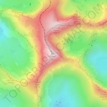
Name: Snowdon topographic map, elevation, terrain.
Location: Snowdon, Gwynedd, Wales, LL55 4UL, United Kingdom (53.06844 -4.07628 53.06854 -4.07618)
Average elevation: 692 m
Minimum elevation: 390 m
Maximum elevation: 1,061 m
Thank you for supporting this site ❤️
Make a donation
Make a donation