
Bridgwater topographic map
Interactive map
Click on the map to display elevation.
About this map
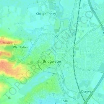
Name: Bridgwater topographic map, elevation, terrain.
Location: Bridgwater, Somerset, England, United Kingdom (51.11317 -3.03567 51.15061 -2.97052)
Average elevation: 10 m
Minimum elevation: 2 m
Maximum elevation: 36 m
Other topographic maps
Click on a map to view its topography, its elevation and its terrain.
Wiveliscombe
United Kingdom > England > Somerset
Wiveliscombe, Somerset, England, United Kingdom
Average elevation: 166 m
Leigh upon Mendip
United Kingdom > England > Somerset
Leigh upon Mendip, Somerset, England, BA3 5QQ, United Kingdom
Average elevation: 177 m
Mells
United Kingdom > England > Somerset
Mells, Somerset, England, United Kingdom
Average elevation: 133 m
Pawlett
United Kingdom > England > Somerset
Pawlett, Somerset, England, United Kingdom
Average elevation: 6 m