Geolocate

Henderson-Massey topographic map

Interactive map

Click on the map to display elevation.

About this map

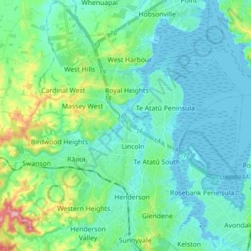
Name: Henderson-Massey topographic map, elevation, terrain.

Location: Henderson-Massey, Auckland, New Zealand (-36.90478 174.58131 -36.79326 174.69477)

Average elevation: 34 m

Minimum elevation: -1 m

Maximum elevation: 181 m

Auckland trails, hiking, mountain biking, running and outdoor activities

Other topographic maps

Click on a map to view its topography, its elevation and its terrain.

Auckland

New Zealand > Auckland

The Auckland Volcanic Field has contributed greatly to the growth and prosperity of the Auckland Region since the area was settled by humans. Initially, the maunga (scoria cones) were occupied and established as pā (fortified settlements) by Māori due to the strategic advantage their elevation provided in…

Average elevation: 32 m

Bombay

New Zealand > Auckland > Franklin

Average elevation: 179 m

Mauku

New Zealand > Auckland > Franklin > Patumāhoe

Average elevation: 60 m

Huapai

New Zealand > Auckland > Rodney

Average elevation: 52 m

Ōrākei Basin

New Zealand > Auckland > Ōrākei

Average elevation: 29 m

Mount Eden Summit

New Zealand > Auckland > Albert-Eden

Average elevation: 81 m

Ahuroa

New Zealand > Auckland > Rodney

Average elevation: 100 m

Woodhill

New Zealand > Auckland > Rodney

Average elevation: 43 m

Ararimu

New Zealand > Auckland > Franklin

Average elevation: 199 m

Ihumātao

New Zealand > Auckland > Māngere-Ōtāhuhu

Average elevation: 8 m

Auckland

New Zealand > Auckland

The Auckland Volcanic Field has contributed greatly to the growth and prosperity of the Auckland region since the area was settled by humans. Initially, the maunga (scoria cones) were occupied and established as pā (fortified settlements) by Māori due to the strategic advantage their elevation provided in…

Average elevation: 32 m

Woodhill

New Zealand > Auckland > Rodney

Average elevation: 43 m

Bombay

New Zealand > Auckland > Franklin

Average elevation: 179 m

Beachlands

New Zealand > Auckland > Franklin

Average elevation: 18 m

Algies Bay

New Zealand > Auckland > Rodney

Average elevation: 19 m

Centre Point

New Zealand > Auckland > Waiheke

Average elevation: 59 m

Ōrākei Basin

New Zealand > Auckland > Ōrākei

Average elevation: 29 m

Pākiri

New Zealand > Auckland > Rodney

Average elevation: 80 m

Auckland

New Zealand > Auckland

The Auckland Volcanic Field has contributed greatly to the growth and prosperity of the Auckland region since the area was settled by humans. Initially, the maunga (scoria cones) were occupied and established as pā (fortified settlements) by Māori due to the strategic advantage their elevation provided in…

Average elevation: 32 m

Kohuora Park

New Zealand > Auckland > Ōtara-Papatoetoe

Average elevation: 21 m

Point Wells

New Zealand > Auckland > Rodney

Average elevation: 22 m

Auckland

New Zealand > Auckland

The Auckland Volcanic Field has contributed greatly to the growth and prosperity of the Auckland Region since the area was settled by humans. Initially, the maunga (scoria cones) were occupied and established as pā (fortified settlements) by Māori due to the strategic advantage their elevation provided in…

Average elevation: 32 m

Pukekohe

New Zealand > Auckland > Franklin

Average elevation: 78 m

Ararimu

New Zealand > Auckland > Franklin

Average elevation: 199 m

Taupaki Estate

New Zealand > Auckland > Rodney > Kumeū

Average elevation: 37 m

Pukekawa

New Zealand > Auckland > Franklin

Average elevation: 84 m

Patumāhoe

New Zealand > Auckland > Franklin

Average elevation: 54 m

Āwhitu Central

New Zealand > Auckland > Franklin

Average elevation: 110 m

Paerata

New Zealand > Auckland > Franklin

Average elevation: 48 m

Ramarama

New Zealand > Auckland > Franklin

Average elevation: 42 m

Wellsford

New Zealand > Auckland > Rodney

Average elevation: 56 m

Waitoki

New Zealand > Auckland > Rodney

Average elevation: 47 m

Hibiscus Coast

New Zealand > Auckland

Average elevation: 40 m

Algies Bay

New Zealand > Auckland > Rodney

Average elevation: 19 m

Pukekohe

New Zealand > Auckland > Franklin

Average elevation: 78 m

Hibiscus Coast

New Zealand > Auckland

Average elevation: 40 m

Auckland

New Zealand > Auckland

The Auckland Volcanic Field has contributed greatly to the growth and prosperity of the Auckland Region since the area was settled by humans. Initially, the maunga (scoria cones) were occupied and established as pā (fortified settlements) by Māori due to the strategic advantage their elevation provided in…

Average elevation: 32 m

Silent Valley

New Zealand > Auckland > Franklin

Average elevation: 211 m

Kumeū

New Zealand > Auckland > Rodney

Average elevation: 48 m

Omaha Beach

New Zealand > Auckland > Rodney > Omaha

Average elevation: 3 m

Stillwater

New Zealand > Auckland > Hibiscus and Bays

Average elevation: 36 m

Wade Heads

New Zealand > Auckland > Hibiscus Coast

Average elevation: 24 m

Beachlands

New Zealand > Auckland > Franklin

Average elevation: 18 m

Drury

New Zealand > Auckland > Papakura

Average elevation: 46 m

Upper Lake

New Zealand > Auckland > Manurewa

Average elevation: 57 m

Ōmaha Flats

New Zealand > Auckland > Rodney > Matakana

Average elevation: 32 m

Beachlands

New Zealand > Auckland > Franklin

Average elevation: 18 m

Hibiscus Coast

New Zealand > Auckland

Average elevation: 40 m

Hibiscus Coast

New Zealand > Auckland

Average elevation: 40 m

Sandspit

New Zealand > Auckland > Sandspit

Average elevation: 26 m

Waiuku

New Zealand > Auckland > Franklin

Average elevation: 32 m

Warkworth

New Zealand > Auckland > Rodney

Average elevation: 61 m

Whitford

New Zealand > Auckland > Franklin

Average elevation: 46 m

Wairau Creek

New Zealand > Auckland > Whau

Average elevation: 20 m

Big Bay

New Zealand > Auckland > Franklin > Big Bay

Average elevation: 25 m

Clevedon

New Zealand > Auckland > Franklin > Clevedon

Average elevation: 37 m