
Make a donation
Dartmoor National Park topographic map
Click on the map to display elevation.
Make a donation
Dartmoor National Park
Rainfall tends to be associated with Atlantic depressions or with convection. In summer, convection caused by solar surface heating sometimes forms shower clouds and a large proportion of rainfall falls from showers and thunderstorms at this time of year. The wettest months are November and December and on the highest parts of the moor the average annual total rainfall is over 2,000 millimetres (79 in). This compares with less than 800 millimetres (31 in) in the lower land to the east around the Exe Estuary, which is in the rain shadow of the moor. Due to the influence of the Gulf Stream snowfall is not common, though due to its high altitude it is more vulnerable to snowfall than surrounding regions.
Make a donation
About this map
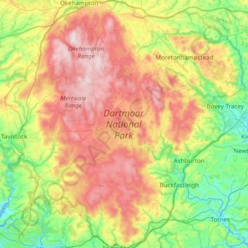
Name: Dartmoor National Park topographic map, elevation, terrain.
Location: Dartmoor National Park, Devon, England, United Kingdom (50.39200 -4.16578 50.74105 -3.63158)
Average elevation: 239 m
Minimum elevation: -2 m
Maximum elevation: 616 m
Make a donation
Other topographic maps
Click on a map to view its topography, its elevation and its terrain.
Haytor Rocks
United Kingdom > England > Devon > Teignbridge > Haytor Vale > Smallacombe
Average elevation: 354 m
Make a donation