
Make a donation
Dunedin City topographic map
Click on the map to display elevation.
Make a donation
About this map
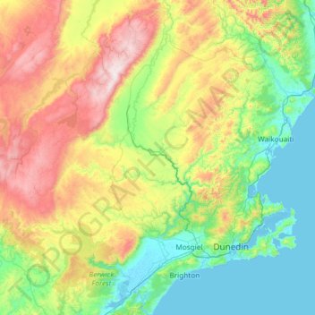
Name: Dunedin City topographic map, elevation, terrain.
Location: Dunedin City, Otago, New Zealand (-46.05193 169.73648 -45.22897 170.75088)
Average elevation: 400 m
Minimum elevation: -2 m
Maximum elevation: 1,441 m
Otago trails, hiking, mountain biking, running and outdoor activities
Make a donation
Other topographic maps
Click on a map to view its topography, its elevation and its terrain.
Dunedin
New Zealand > Otago > Dunedin City
The climate of Dunedin in general is temperate. The city is recognised as having a large number of microclimates and the weather conditions often vary between suburbs mostly due to the city's topographical layout. Under the Köppen climate classification, Dunedin features an oceanic climate. The city's climate…
Average elevation: 110 m
The Remarkables
New Zealand > Otago > Queenstown-Lakes District
The area contains a number of beautiful features, such as Lake Alta, a small lake nestled within a natural amphitheatre at the head of a glacial valley (a ‘cirque’) and below the towering Double Cone peaks. There are a number of high altitude walks in the Remarkables Conservation Area including Lake Alta…
Average elevation: 1,200 m
Ranfurly
New Zealand > Otago > Central Otago District > Maniototo Community
Ranfurly is a town in the Central Otago District of Otago, New Zealand. Located 110 kilometres (68 miles) north of Dunedin, it lies in the dry rough plain of Maniototo at a moderately high altitude (around 430 metres or 1,410 feet above sea level) close to a small tributary of the Taieri River. It operates as…
Average elevation: 428 m
Make a donation
Queenstown
New Zealand > Otago > Queenstown-Lakes District
The town is at a relatively low altitude for a ski and snowboarding centre, at 310 metres (1,020 ft) above sea level at the lake shore, but is nestled among mountains, most notably the scenic attraction of The Remarkables, to the town's southeast. Below the lake lies the deep Kawarau Gorge, and there are…
Average elevation: 592 m
Make a donation
Make a donation
Bannockburn
New Zealand > Otago > Central Otago District > Cromwell Community
Average elevation: 279 m
Make a donation
Clyde Dam
New Zealand > Otago > Central Otago District > Vincent Community > Clyde
Average elevation: 318 m
Make a donation
Saint Bathans Range
New Zealand > Otago > Central Otago District > Cromwell Community
Average elevation: 1,222 m
Make a donation
Hawkdun Range
New Zealand > Otago > Central Otago District > Vincent Community
Average elevation: 1,112 m
Pātearoa / Rock And Pillar Range
New Zealand > Otago > Central Otago District > Maniototo Community
The vegetation of the high elevation habitats of the Rock and Pillar Range has been the subject of numerous studies by New Zealand botanist Alan Mark and colleagues. The Rock and Pillar Range has a similar alpine vegetation to other mountain ranges in Central Otago, such as the Old Man Range. In the Rock and…
Average elevation: 937 m
Make a donation
Make a donation
Queenstown
New Zealand > Otago > Queenstown-Lakes District
The town is at a relatively low altitude for a ski and snowboarding centre, at 310 metres (1,020 ft) above sea level at the lake shore, but is nestled among mountains, most notably the scenic attraction of The Remarkables, to the town's southeast. Below the lake lies the deep Kawarau Gorge, and there are…
Average elevation: 592 m
Make a donation
Dunedin
New Zealand > Otago > Dunedin City
The climate of Dunedin in general is temperate. The city is recognised as having a large number of microclimates and the weather conditions often vary between suburbs mostly due to the city's topographical layout. Under the Köppen climate classification, Dunedin features an oceanic climate. The city's climate…
Average elevation: 110 m
Queenstown
New Zealand > Otago > Queenstown-Lakes District
The town is at a relatively low altitude for a ski and snowboarding centre, at 310 metres (1,020 ft) above sea level at the lake shore, but is nestled among mountains, most notably the scenic attraction of The Remarkables, to the town's southeast. Below the lake lies the deep Kawarau Gorge, and there are…
Average elevation: 592 m
Naseby
New Zealand > Otago > Central Otago District > Maniototo Community
Naseby is a small town in the Maniototo region of Central Otago, New Zealand. The town catch phrase is "2000 feet above worry level" indicating its altitude. The town is 140 km (90 mi) from Dunedin. The centre of the town is a registered historic area, and there are many heritage buildings. Naseby has hot…
Average elevation: 619 m
Make a donation
Make a donation
Mount Kāmaka
New Zealand > Otago > Central Otago District > Cromwell Community
Average elevation: 905 m
Make a donation
Make a donation
Make a donation
Queenstown
New Zealand > Otago > Queenstown-Lakes District
The town is at a relatively low altitude for a ski and snowboarding centre, at 310 metres (1,020 ft) above sea level at the lake shore, but is nestled among mountains, most notably the scenic attraction of The Remarkables, to the town's southeast. Below the lake lies the deep Kawarau Gorge, and there are…
Average elevation: 592 m
Ettrick
New Zealand > Otago > Central Otago District > Teviot Valley Community
Average elevation: 105 m
Make a donation
Queenstown
New Zealand > Otago > Queenstown-Lakes District
The town is at a relatively low altitude for a ski and snowboarding centre, at 310 metres (1,020 ft) above sea level at the lake shore, but is nestled among mountains, most notably the scenic attraction of The Remarkables, to the town's southeast. Below the lake lies the deep Kawarau Gorge, and there are…
Average elevation: 592 m
Make a donation
Ranfurly
New Zealand > Otago > Central Otago District
Ranfurly is a town in the Central Otago District of Otago, New Zealand. Located 110 kilometres (68 miles) north of Dunedin, it lies in the dry rough plain of Maniototo at a moderately high altitude (around 430 metres or 1,410 feet above sea level) close to a small tributary of the Taieri River. It operates as…
Average elevation: 428 m
Queenstown
New Zealand > Otago > Queenstown-Lakes District
The town is at a relatively low altitude for a ski and snowboarding centre, at 310 metres (1,020 ft) above sea level at the lake shore, but is nestled among mountains, most notably the scenic attraction of The Remarkables, to the town's southeast. Below the lake lies the deep Kawarau Gorge, and there are…
Average elevation: 592 m
Make a donation
Bannockburn
New Zealand > Otago > Central Otago District > Cromwell Community
Average elevation: 279 m
Make a donation
Make a donation
Make a donation
Queenstown
New Zealand > Otago > Queenstown-Lakes District
The town is at a relatively low altitude for a ski and snowboarding centre, at 310 metres (1,020 ft) above sea level at the lake shore, but is nestled among mountains, most notably the scenic attraction of The Remarkables, to the town's southeast. Below the lake lies the deep Kawarau Gorge, and there are…
Average elevation: 592 m
Central Otago
New Zealand > Otago > Central Otago District > Vincent Community
Average elevation: 935 m
Make a donation
Dunedin
New Zealand > Otago > Dunedin City
The climate of Dunedin in general is temperate. The city is recognised as having a large number of microclimates and the weather conditions often vary between suburbs mostly due to the city's topographical layout. Under the Köppen climate classification, Dunedin features an oceanic climate. The city's climate…
Average elevation: 110 m
Make a donation
Cromwell
New Zealand > Otago > Central Otago District > Cromwell Community > Cromwell
Average elevation: 330 m
Waiareka Junction
New Zealand > Otago > Waitaki District > Oamaru > Waiareka Junction
Average elevation: 63 m
Make a donation