
Make a donation
New Guinea topographic map
Click on the map to display elevation.
Make a donation
New Guinea
A spine of east–west mountains, the New Guinea Highlands, dominates the geography of New Guinea, stretching over 1,600 km (1,000 mi) across the island, with many mountains over 4,000 m (13,100 ft). The western half of the island contains the highest mountains in Oceania, with its highest point, Puncak Jaya, reaching an elevation of 4,884 m (16,023 ft). The tree line is around 4,000 m (13,100 ft) elevation, and the tallest peaks contain equatorial glaciers—which have been retreating since at least 1936. Various other smaller mountain ranges occur both north and west of the central ranges. Except in high elevations, most areas possess a warm humid climate throughout the year, with some seasonal variation associated with the northeast monsoon season.
Make a donation
About this map
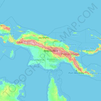
Name: New Guinea topographic map, elevation, terrain.
Location: New Guinea, Southern Region, Papua New Guinea (-10.70169 130.93155 -0.34330 150.87629)
Average elevation: 101 m
Minimum elevation: -4 m
Maximum elevation: 4,441 m
Make a donation
Other topographic maps
Click on a map to view its topography, its elevation and its terrain.
Mount Hagen
Papua New Guinea > Western Highlands > Mount Hagen District
Mount Hagen (Tok Pisin: Maun Hagen) is the third largest city in Papua New Guinea, with a population of 46,250. It is the capital of the Western Highlands Province and is located in the large fertile Wahgi Valley in central mainland Papua New Guinea, at an elevation of 1,677 m (5,502 ft).
Average elevation: 1,904 m
Make a donation
Make a donation